Paypay:Zhou dynasty 1000 BC.png
Waray mas hiruhitaas nga resolusyon.
Zhou_dynasty_1000_BC.png (318 × 344 nga pixel, kadako han fayl: 27 nga KB, MIME nga tipo: image/png)
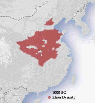
| Tigtulidong | The approximate territory of the Zhou dynasty in China. Drawn by Ian Kiu. Derived from China_map.png by Nat. |
| Petsa | (UTC) |
| Ginkuhaan |
|
| Awtor |
I, the copyright holder of this work, hereby publish it under the following licenses:
| Ini nga file in nakalisensya ha ilarom han Creative Commons Attribution-Share Alike 3.0 Unported license. | ||
| ||
| This licensing tag was added to this file as part of the GFDL licensing update. |

|
An permiso in ginhatag ha pagkopya, pagpakalat ngan/o pagliwat hinin nga dokumento ha ilarom han mga termino han GNU Free Documentation License, Version 1.2 o mas uruurhi nga version nga ginmantala han Free Software Foundation; nga may-ada waray Invariant Sections, waray Front-Cover Texts, ngan waray Back-Cover Texts. May-ada kopya hin lisensya nga ginlalakip ha seksyon nga may-ada pamagat nga GNU Free Documentation License. |
Puydi ka pumili hin lisenysa nga karuyag mo.
Original upload log
This image is a derivative work of the following images:
- File:Territories_of_Dynasties_in_China.gif licensed with Cc-by-sa-3.0-migrated, GFDL
- 2008-06-10T02:16:34Z Wengier 556x537 (330452 Bytes) {{Information |Description=small fix |Source=based on previous version |Date=Jun 10, 2008 |Author= |Permission= |other_versions= }}
- 2008-02-28T03:05:10Z Roke 556x537 (280307 Bytes) == Summary == Image from wikipedia of same name (The picture above cycles so spend your time carefuly.) {{Information |Description=The approximate territories of dynasties in China. Drawn by Ia
Uploaded with derivativeFX
Albert Herrmann (1935). History and Commercial Atlas of China. Harvard University Press.
Kaagi han paypay
Pidlita an adlaw/oras para makit-an an fayl nga naggawas hito nga oras.
| Pitsa/Oras | Thumbnail | Mga dimensyon | Gumaramit | Komento | |
|---|---|---|---|---|---|
| waray pa kasasapawi | 16:21, 15 Pebrero 2011 | | 318 × 344 (27 nga KB) | Malus Catulus | {{Information |Description=The approximate territory of the Zhou dynasty in China. Drawn by Ian Kiu. Derived from [http://en.wikipedia.org/wiki/Image:China_map.png China_map.png] by Nat. |Source=*File:Territories_of_Dynasties_in_China.gif: from "The |
Mga Sumpay
An mga nasunod nga mga pakli nasumpay hini nga paypay:
Global file usage
An masunod nga iba nga mga wiki in nagamit hini nga file:
- Paggamit ha am.wikipedia.org
- Paggamit ha ast.wikipedia.org
- Paggamit ha as.wikipedia.org
- Paggamit ha ba.wikipedia.org
- Paggamit ha be.wikipedia.org
- Paggamit ha bg.wikipedia.org
- Paggamit ha bn.wikipedia.org
- Paggamit ha ckb.wikipedia.org
- Paggamit ha cs.wikipedia.org
- Paggamit ha de.wikipedia.org
- Paggamit ha el.wikipedia.org
- Paggamit ha en.wikipedia.org
- Paggamit ha es.wikipedia.org
- Paggamit ha eu.wikipedia.org
- Paggamit ha fa.wikipedia.org
- Paggamit ha fi.wikipedia.org
- Paggamit ha fr.wikipedia.org
- Paggamit ha gl.wikipedia.org
- Paggamit ha hak.wikipedia.org
- Paggamit ha he.wikipedia.org
- Paggamit ha hi.wikipedia.org
- Paggamit ha hr.wikipedia.org
- Paggamit ha hy.wikipedia.org
- Paggamit ha incubator.wikimedia.org
- Paggamit ha ka.wikipedia.org
- Paggamit ha ko.wikipedia.org
- Paggamit ha ku.wikipedia.org
- Paggamit ha la.wikipedia.org
- Paggamit ha lfn.wikipedia.org
- Paggamit ha lv.wikipedia.org
- Paggamit ha ml.wikipedia.org
- Paggamit ha mn.wikipedia.org
- Paggamit ha ms.wikipedia.org
- Paggamit ha mt.wikipedia.org
- Paggamit ha my.wikipedia.org
- Paggamit ha new.wikipedia.org
Kitaa durudamo nga global usage hinin nga file.