Paypay:USGS-MarsMap-sim3292-20140714-crop.png

Orihinal nga paypay(3,773 × 4,249 nga pixel, kadako han fayl: 8.88 nga MB, MIME nga tipo: image/png)

An fayl in tikang ha Wikimedia Commons ngan puydi mahigamitan para han iba nga mga proyekto. An paglaladawan han iya fayl han paglaladawan nga pakli didto in ginpapakita ha sirong.

Dalikyat nga pulong

Tigtulidong
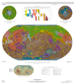
English: USGS - Geologic Map of Mars - 2014 -

July 14, 2014

http://pubs.usgs.gov/sim/3292/

---

NOTE: CROP by Dr. Dennis Bogdan (Drbogdan) - converted original PDF image (http://pubs.usgs.gov/sim/3292/pdf/sim3292_map.pdf) to PNG image via GIMP v2.8 & cropped with PSP v6.2 - July 22, 2014.

NOTE: FULL IMAGE => File:USGS-MarsMap-sim3292-20140714-full.png - derived from original PDF image at => http://pubs.usgs.gov/sim/3292/pdf/sim3292_map.pdf

ALSO RELATED:

---

By Kenneth L. Tanaka, James A. Skinner, Jr., James M. Dohm, Rossman P. Irwin, III, Eric J. Kolb, Corey M. Fortezzo, Thomas Platz, Gregory G. Michael, and Trent M. Hare

ABSTRACT

This global geologic map of Mars, which records the distribution of geologic units and landforms on the planet's surface through time, is based on unprecedented variety, quality, and quantity of remotely sensed data acquired since the Viking Orbiters. These data have provided morphologic, topographic, spectral, thermophysical, radar sounding, and other observations for integration, analysis, and interpretation in support of geologic mapping. In particular, the precise topographic mapping now available has enabled consistent morphologic portrayal of the surface for global mapping (whereas previously used visual-range image bases were less effective, because they combined morphologic and albedo information and, locally, atmospheric haze). Also, thermal infrared image bases used for this map tended to be less affected by atmospheric haze and thus are reliable for analysis of surface morphology and texture at even higher resolution than the topographic products.
Petsa
Ginkuhaan http://pubs.usgs.gov/sim/3292/pdf/sim3292_map.pdf
Awtor USGS
Other versions

Palilisensya:

Public domain
This image is in the public domain in the United States because it only contains materials that originally came from the United States Geological Survey, an agency of the United States Department of the Interior. For more information, see the official USGS copyright policy.

Bahasa Indonesia  català  čeština  Deutsch  eesti  English  español  français  galego  italiano  Nederlands  português  polski  sicilianu  suomi  Tiếng Việt  Türkçe  български  македонски  русский  മലയാളം  한국어  日本語  中文  中文(简体)  中文(繁體)  العربية  فارسی  +/−

Captions

Add a one-line explanation of what this file represents

Items portrayed in this file

depicts English

inception English

23 Hulyo 2014

media type English

image/png

Kaagi han paypay

Pidlita an adlaw/oras para makit-an an fayl nga naggawas hito nga oras.

Pitsa/OrasThumbnailMga dimensyonGumaramitKomento
waray pa kasasapawi17:03, 6 Nobyembre 2014Bersyon han thumbnail han 17:03, 6 Nobyembre 20143,773 × 4,249 (8.88 nga MB)Kopiersperreoptipng
21:07, 23 Hulyo 2014Bersyon han thumbnail han 21:07, 23 Hulyo 20143,773 × 4,249 (11.03 nga MB)DrbogdanUser created page with UploadWizard

Waray pakli nga nagamit hinin nga file.

Global file usage

An masunod nga iba nga mga wiki in nagamit hini nga file:

Metadata