Paypay:Thuringia location map.svg

Size of this PNG preview of this SVG file: 764 × 599 nga mga pixel. Iba nga mga resolusyon: 306 × 240 nga mga pixel | 612 × 480 nga mga pixel | 979 × 768 nga mga pixel | 1,280 × 1,004 nga mga pixel | 2,560 × 2,009 nga mga pixel | 966 × 758 nga mga pixel.
Orihinal nga paypay (SVG nga fayl, ginbabanabanahan nga 966 × 758 nga mga pixel, kadako han fayl: 161 nga KB)
Dalikyat nga pulong
| Tigtulidong |
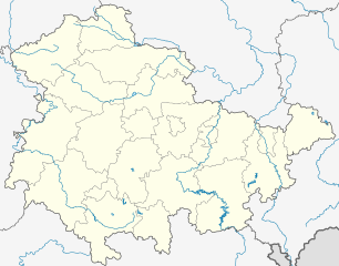
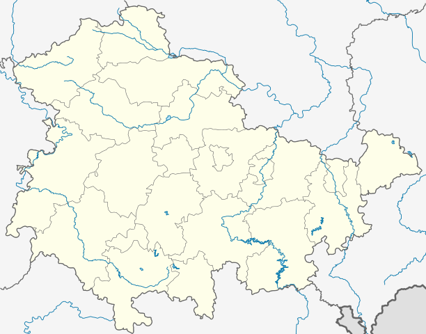
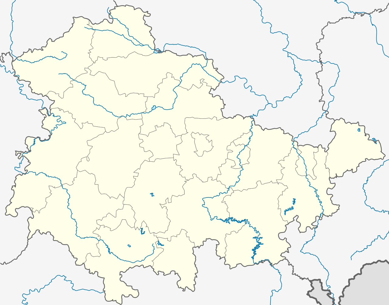
Deutsch: Positionskarte Thüringen, Deutschland. Geographische Begrenzung der Karte:
English: Location map Thuringia, Germany. Geographic limits of the map:
|
|||
| Petsa | ||||
| Ginkuhaan |
own work, templates were:
|
|||
| Awtor | TUBS | |||
| Other versions |
Derivative works of this file: Location map of the scope of the Rhein-Main-Verkehrsverbund.svg
|
|||
| SVG genesis | This map was created with Adobe Illustrator, and with Inkscape.
|


Palilisensya:
I, the copyright holder of this work, hereby publish it under the following licenses:

|
An permiso in ginhatag ha pagkopya, pagpakalat ngan/o pagliwat hinin nga dokumento ha ilarom han mga termino han GNU Free Documentation License, Version 1.2 o mas uruurhi nga version nga ginmantala han Free Software Foundation; nga may-ada waray Invariant Sections, waray Front-Cover Texts, ngan waray Back-Cover Texts. May-ada kopya hin lisensya nga ginlalakip ha seksyon nga may-ada pamagat nga GNU Free Documentation License. |
This file is licensed under the Creative Commons Attribution-Share Alike 3.0 Unported, 2.5 Generic, 2.0 Generic and 1.0 Generic license.
- Talwas ka:
- para han pagpasaro – para han pagkopya, pagpakalat ngan pagpadangat han buhat
- para han pagremix – pag-adapt han buhat
- Ha ilarom an masunod nga mga kondisyon:
- attribution – Kinahanglanon mo tagan hin kaangayan nga credit, paghatag hin sumpay ngadto ha lisensya, ngan igbutang an imo ginbag-ohan nga binuhat. Puydi mo ini buhaton ha bisan ano nga resonable nga pamaagi, pero diri nimo pagawson nga an naghatag hin lisensya nag-eendorso ha imo o ha imo paggamit.
- share alike – Kun imo ginsagol-hin-otro, gin-iba, o gin-hingayad han buhat, ikaw in angay gud là magpakalat han imo gin-amot ha ilarom la han [http:creativecommons.org/share-your-work/licensing-considerations/compatible-licenses pareho o naangay nga lisensya] sugad han orihinal.
Puydi ka pumili hin lisenysa nga karuyag mo.
Kaagi han paypay
Pidlita an adlaw/oras para makit-an an fayl nga naggawas hito nga oras.
| Pitsa/Oras | Thumbnail | Mga dimensyon | Gumaramit | Komento | |
|---|---|---|---|---|---|
| waray pa kasasapawi | 19:35, 31 Disyembre 2023 | | 966 × 758 (161 nga KB) | NordNordWest | upd |
| 11:10, 31 Disyembre 2022 |  | 966 × 758 (161 nga KB) | NordNordWest | upd | |
| 17:47, 30 Hunyo 2021 |  | 966 × 758 (161 nga KB) | NordNordWest | upd | |
| 12:08, 30 Disyembre 2018 |  | 966 × 758 (162 nga KB) | NordNordWest | upd 2019 | |
| 18:11, 11 Oktubre 2009 |  | 966 × 758 (642 nga KB) | Alexrk2 | Landesgrenze und vereinzelt Flussläufe korrigiert | |
| 00:44, 31 Enero 2009 |  | 966 × 758 (670 nga KB) | TUBS | Improved rivers outside thuringia | |
| 00:09, 29 Enero 2009 |  | 966 × 758 (732 nga KB) | TUBS | == Summary == {{Information |Description= {{de|Positionskarte Thüringen, Deutschland. Geographische Begrenzung der Karte:}} {{en|Location map Thuringia, Germany. Geographic limits of the map:}} * N: 50.xx° N * S: 4 | |
| 00:00, 29 Enero 2009 |  | 966 × 758 (732 nga KB) | TUBS | == Summary == {{Information |Description= {{de|Positionskarte Thüringen, Deutschland. Geographische Begrenzung der Karte:}} {{en|Location map Thuringia, Germany. Geographic limits of the map:}} * N: 50.xx° N * S: 4 | |
| 23:43, 28 Enero 2009 |  | 966 × 758 (734 nga KB) | TUBS | == Summary == {{Information |Description= {{de|Positionskarte Thüringen, Deutschland. Geographische Begrenzung der Karte:}} {{en|Location map Thuringia, Germany. Geographic limits of the map:}} * N: 50.xx° N * S: 4 |
Mga Sumpay
An mga nasunod nga mga pakli nasumpay hini nga paypay:
Global file usage
An masunod nga iba nga mga wiki in nagamit hini nga file:
- Paggamit ha ar.wikipedia.org
- Paggamit ha azb.wikipedia.org
- Paggamit ha ba.wikipedia.org
- Абтсбессинген
- Айзенах
- Айзенберг (Тюрингия)
- Айнеборн
- Айнхаузен (Тюрингия)
- Айсфельд
- Айхенберг (Йена)
- Айхенберг (Хильдбургхаузен)
- Айхструт
- Аллендорф (Тюрингия)
- Альберсдорф (Тюрингия)
- Алькерслебен
- Альперштедт
- Альтенберга
- Альтенбойтен
- Альтенбург
- Альтенготтерн
- Альтенфельд
- Альтерсбах
- Альткирхен
- Альштедт
- Ангельрода
- Анденхаузен
- Андислебен
- Анроде
- Апольда
- Апфельштедт
- Аренсхаузен
- Арнсгеройт
- Арнштадт
- Артерн (Унструт)
- Асбах-Зикенберг
- Аспах (Тюрингия)
- Аулебен
- Аума
- Ауэнгрунд
- Ауэрштедт
- Ашенхаузен
- Бёлен (Тюрингия)
- Бёслебен-Вюллерслебен
- Бад-Берка
- Бад-Бланкенбург
- Бад-Зальцунген
- Бад-Зульца
Kitaa durudamo nga global usage hinin nga file.