Paypay:Thailand Bueng Kan locator map.svg

Size of this PNG preview of this SVG file: 341 × 599 nga mga pixel. Iba nga mga resolusyon: 136 × 240 nga mga pixel | 273 × 480 nga mga pixel | 437 × 768 nga mga pixel | 582 × 1,024 nga mga pixel | 1,165 × 2,048 nga mga pixel | 1,052 × 1,849 nga mga pixel.
Orihinal nga paypay (SVG nga fayl, ginbabanabanahan nga 1,052 × 1,849 nga mga pixel, kadako han fayl: 1.84 nga MB)
| Tigtulidong |
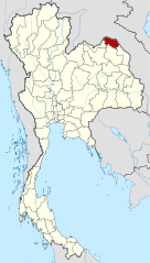
Deutsch: Lagekarte der Provinz Bueng Kan, Thailand English: Locator map of Bueng Kan Province, Thailand |
| Petsa | (UTC) |
| Ginkuhaan | |
| Awtor |
|
| This is a retouched picture, which means that it has been digitally altered from its original version. Modifications: Merged together to show Bueng Kan province. The original can be viewed here: Amphoe Nong Khai.svg:
|
Ini nga file in nakalisensya ha ilarom han Creative Commons Attribution-Share Alike 3.0 Unported license.
- Talwas ka:
- para han pagpasaro – para han pagkopya, pagpakalat ngan pagpadangat han buhat
- para han pagremix – pag-adapt han buhat
- Ha ilarom an masunod nga mga kondisyon:
- attribution – Kinahanglanon mo tagan hin kaangayan nga credit, paghatag hin sumpay ngadto ha lisensya, ngan igbutang an imo ginbag-ohan nga binuhat. Puydi mo ini buhaton ha bisan ano nga resonable nga pamaagi, pero diri nimo pagawson nga an naghatag hin lisensya nag-eendorso ha imo o ha imo paggamit.
- share alike – Kun imo ginsagol-hin-otro, gin-iba, o gin-hingayad han buhat, ikaw in angay gud là magpakalat han imo gin-amot ha ilarom la han [http:creativecommons.org/share-your-work/licensing-considerations/compatible-licenses pareho o naangay nga lisensya] sugad han orihinal.
Original upload log
This image is a derivative work of the following images:
- File:Thailand_Nong_Khai_locator_map.svg licensed with Cc-by-3.0, GFDL
- 2009-04-21T17:01:48Z NordNordWest 1052x1849 (1525269 Bytes) {{Information |Description= {{de|Lagekarte der Provinz Nong Khai, Thailand}} {{en|Locator map of Nong Khai Province, Thailand}} |Source=self-made, using * [[:file:Thailand location map.svg|Thailand location map.svg]] |Date=2
- File:Amphoe_Nong_Khai.svg licensed with Cc-by-sa-3.0
Uploaded with derivativeFX
Kaagi han paypay
Pidlita an adlaw/oras para makit-an an fayl nga naggawas hito nga oras.
| Pitsa/Oras | Thumbnail | Mga dimensyon | Gumaramit | Komento | |
|---|---|---|---|---|---|
| waray pa kasasapawi | 21:27, 6 Agosto 2010 | | 1,052 × 1,849 (1.84 nga MB) | Ahoerstemeier | {{Information |Description={{de|Lagekarte der Provinz Nong Khai, Thailand}} {{en|Locator map of Nong Khai Province, Thailand}} {{en|1=Map of Nong Khai province, Thailand, with the districts (Amphoe) numbered. #Mueang Nong Khai (อำเภอเมื� |
Mga Sumpay
An mga nasunod nga mga pakli nasumpay hini nga paypay:
Global file usage
An masunod nga iba nga mga wiki in nagamit hini nga file:
- Paggamit ha ar.wikipedia.org
- Paggamit ha be.wikipedia.org
- Paggamit ha cdo.wikipedia.org
- Paggamit ha ckb.wikipedia.org
- Paggamit ha de.wikipedia.org
- Paggamit ha de.wikivoyage.org
- Paggamit ha en.wikipedia.org
- Bueng Khong Long district
- Bung Khla district
- Pak Khat district
- Si Wilai district
- Seka district
- So Phisai district
- Bueng Kan province
- Seals of the provinces of Thailand
- Template:BuengKan-geo-stub
- Si Wilai subdistrict
- Chumphu Phon
- Phon Charoen
- Tha Kok Daeng
- Seka subdistrict
- Bueng Khong Long subdistrict
- Dong Bang, Bueng Kan
- Pho Mak Khaeng
- Tha Dok Kham
- Bung Khla subdistrict
- Khok Kwang
- Nong Doen
- Pak Khat subdistrict
- Nong Yong
- Na Kang
- Na Dong
- Non Sila, Bueng Kan
- Som Sanuk
- Don Ya Nang
- Nong Hua Chang
- Pa Faek, Bueng Kan
- Si Chomphu, Phon Charoen
- Si Samran
- Wang Chomphu
- Ban Tong
- Nam Chan
- Nong Thum
- Pong Hai
- Sang, Bueng Kan
- Sok Kam
- Tha Sa-at
- Na Sabaeng
- Na Saeng, Bueng Kan
- Na Sing
Kitaa durudamo nga global usage hinin nga file.