Paypay:South Yorkshire UK locator map 2010.svg

Size of this PNG preview of this SVG file: 494 × 600 nga mga pixel. Iba nga mga resolusyon: 198 × 240 nga mga pixel | 395 × 480 nga mga pixel | 633 × 768 nga mga pixel | 843 × 1,024 nga mga pixel | 1,687 × 2,048 nga mga pixel | 1,108 × 1,345 nga mga pixel.
Orihinal nga paypay (SVG nga fayl, ginbabanabanahan nga 1,108 × 1,345 nga mga pixel, kadako han fayl: 302 nga KB)
Dalikyat nga pulong
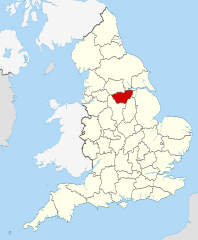
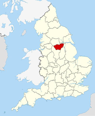
| Tigtulidong | Location of the ceremonial county of South Yorkshire within England. |
| Petsa | |
| Ginkuhaan |
National Geospatial-Intelligence Agency
|
| Awtor | Nilfanion |
Palilisensya:
I, the copyright holder of this work, hereby publish it under the following licenses:
Ini nga file in nakalisensya ha ilarom han Creative Commons Attribution-Share Alike 3.0 Unported license.
- Talwas ka:
- para han pagpasaro – para han pagkopya, pagpakalat ngan pagpadangat han buhat
- para han pagremix – pag-adapt han buhat
- Ha ilarom an masunod nga mga kondisyon:
- attribution – Kinahanglanon mo tagan hin kaangayan nga credit, paghatag hin sumpay ngadto ha lisensya, ngan igbutang an imo ginbag-ohan nga binuhat. Puydi mo ini buhaton ha bisan ano nga resonable nga pamaagi, pero diri nimo pagawson nga an naghatag hin lisensya nag-eendorso ha imo o ha imo paggamit.
- share alike – Kun imo ginsagol-hin-otro, gin-iba, o gin-hingayad han buhat, ikaw in angay gud là magpakalat han imo gin-amot ha ilarom la han [http:creativecommons.org/share-your-work/licensing-considerations/compatible-licenses pareho o naangay nga lisensya] sugad han orihinal.

|
An permiso in ginhatag ha pagkopya, pagpakalat ngan/o pagliwat hinin nga dokumento ha ilarom han mga termino han GNU Free Documentation License, Version 1.2 o mas uruurhi nga version nga ginmantala han Free Software Foundation; nga may-ada waray Invariant Sections, waray Front-Cover Texts, ngan waray Back-Cover Texts. May-ada kopya hin lisensya nga ginlalakip ha seksyon nga may-ada pamagat nga GNU Free Documentation License. |
Puydi ka pumili hin lisenysa nga karuyag mo.

|
This is one of the images forming part of the Valued image set: Locator maps of the Ceremonial counties of England on Wikimedia Commons. The image set has been assessed under the valued image set criteria and is considered the most valued set on Commons within the scope:
Locator maps of the Ceremonial counties of England
You can see its nomination at Commons:Valued image candidates/Locator maps of English ceremonial counties. |
Kaagi han paypay
Pidlita an adlaw/oras para makit-an an fayl nga naggawas hito nga oras.
| Pitsa/Oras | Thumbnail | Mga dimensyon | Gumaramit | Komento | |
|---|---|---|---|---|---|
| waray pa kasasapawi | 22:44, 23 Nobyembre 2010 | | 1,108 × 1,345 (302 nga KB) | Nilfanion | == Summary == {{Information |Description=Location of the ceremonial county of South Yorkshire within England. |Source=Ordnance Survey [https://www.ordnancesurvey.co.uk/opendatadownload/products.html OpenData]: * |
Mga Sumpay
An mga nasunod nga mga pakli nasumpay hini nga paypay:
Global file usage
An masunod nga iba nga mga wiki in nagamit hini nga file:
- Paggamit ha af.wikipedia.org
- Paggamit ha an.wikipedia.org
- Paggamit ha arz.wikipedia.org
- Paggamit ha ast.wikipedia.org
- Paggamit ha be-tarask.wikipedia.org
- Paggamit ha bg.wikipedia.org
- Paggamit ha bn.wikipedia.org
- Paggamit ha ca.wikipedia.org
- Paggamit ha ceb.wikipedia.org
- Paggamit ha cs.wikipedia.org
- Paggamit ha dag.wikipedia.org
- Paggamit ha en.wikipedia.org
- South Yorkshire
- Five Weirs Walk
- Attercliffe Chapel
- Kendray
- Gildingwells
- Moorends
- Clayton, South Yorkshire
- Great Houghton, South Yorkshire
- Staincross
- Mapplewell
- Cubley, South Yorkshire
- Barugh, South Yorkshire
- Barugh Green
- Ingbirchworth
- Jump, South Yorkshire
- Gawber
- Little Houghton, South Yorkshire
- Silkstone Common
- Stairfoot
- Gilroyd
- Wilthorpe
- New Lodge, South Yorkshire
- Wharncliffe Side
- Richmond, Sheffield
- Ranmoor
- Graves Park (ward)
- Belle Vue, South Yorkshire
- Shiregreen and Brightside
- Deepcar
- East Ecclesfield
- West Ecclesfield
- Fenwick, South Yorkshire
- Thorpe Hesley
- Brodsworth Colliery
- Parkgate, South Yorkshire
- Highfields, South Yorkshire
- Rother Valley Country Park
Kitaa durudamo nga global usage hinin nga file.