Paypay:Snowfield Peak 8648s.JPG

Kadako hin nga pahiuna nga pagawas: 800 × 450 nga mga pixel. Iba nga mga resolusyon: 320 × 180 nga mga pixel | 640 × 360 nga mga pixel | 1,024 × 576 nga mga pixel | 1,280 × 720 nga mga pixel | 2,560 × 1,441 nga mga pixel | 6,892 × 3,879 nga mga pixel.
Orihinal nga paypay (6,892 × 3,879 nga pixel, kadako han fayl: 8.78 nga MB, MIME nga tipo: image/jpeg)
Dalikyat nga pulong
| Tigtulidong |
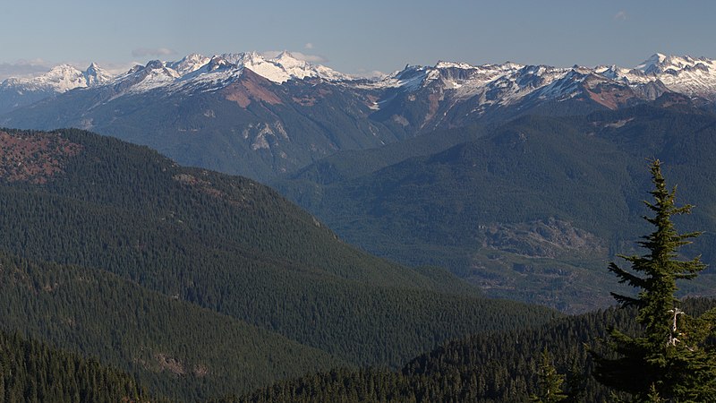
English: View across the Skagit River Valley of the northern portion of the south unit of North Cascades National Park: Snowfield Peak (left center skyline with cloud behind); The Needle (skyline, left of cloud); Big Devil Peak (middle distance); The Trapezoid (middle distance, centered below small cloud); Paul Bunyans Stump (skyline with shadowed north face); Pinnacle Peak (left skyline); Primus Peak (right skyline above Tsuga mertensiana in foreground; Little Devil Peak (middle distance skyline, left of Primus Peak)
|
| Petsa | 28 Oktubre 2013, 20:09:19 +00:00 |
| Ginkuhaan | Kalugaringon nga buhat |
| Awtor | Walter Siegmund (talk) |
| Other versions |
|


| Camera location | | View this and other nearby images on: OpenStreetMap |
|---|
| Camera Model | Canon EOS DIGITAL REBEL XSi |
|---|---|
| Shutter speed | 1/200 |
| Aperture | f/11.0 |
| Film speed (ISO) | 400 |
| Focal length | 100.0 |
| Filter(s) | Hoya Circular Polarizer, HOCPMC67 |

|
This image is the work of Walter Siegmund
|
Palilisensya:
I, the copyright holder of this work, hereby publish it under the following license:
Ini nga file in nakalisensya ha ilarom han Creative Commons Attribution-Share Alike 3.0 Unported license.
- Talwas ka:
- para han pagpasaro – para han pagkopya, pagpakalat ngan pagpadangat han buhat
- para han pagremix – pag-adapt han buhat
- Ha ilarom an masunod nga mga kondisyon:
- attribution – Kinahanglanon mo tagan hin kaangayan nga credit, paghatag hin sumpay ngadto ha lisensya, ngan igbutang an imo ginbag-ohan nga binuhat. Puydi mo ini buhaton ha bisan ano nga resonable nga pamaagi, pero diri nimo pagawson nga an naghatag hin lisensya nag-eendorso ha imo o ha imo paggamit.
- share alike – Kun imo ginsagol-hin-otro, gin-iba, o gin-hingayad han buhat, ikaw in angay gud là magpakalat han imo gin-amot ha ilarom la han [http:creativecommons.org/share-your-work/licensing-considerations/compatible-licenses pareho o naangay nga lisensya] sugad han orihinal.
Kaagi han paypay
Pidlita an adlaw/oras para makit-an an fayl nga naggawas hito nga oras.
| Pitsa/Oras | Thumbnail | Mga dimensyon | Gumaramit | Komento | |
|---|---|---|---|---|---|
| waray pa kasasapawi | 22:03, 14 Enero 2015 | | 6,892 × 3,879 (8.78 nga MB) | Wsiegmund |
Mga Sumpay
An mga nasunod nga mga pakli nasumpay hini nga paypay:
Global file usage
An masunod nga iba nga mga wiki in nagamit hini nga file: