Paypay:Scandinavian States.svg

Size of this PNG preview of this SVG file: 636 × 599 nga mga pixel. Iba nga mga resolusyon: 255 × 240 nga mga pixel | 509 × 480 nga mga pixel | 815 × 768 nga mga pixel | 1,087 × 1,024 nga mga pixel | 2,174 × 2,048 nga mga pixel | 1,090 × 1,027 nga mga pixel.
Orihinal nga paypay (SVG nga fayl, ginbabanabanahan nga 1,090 × 1,027 nga mga pixel, kadako han fayl: 537 nga KB)
| Tigtulidong |
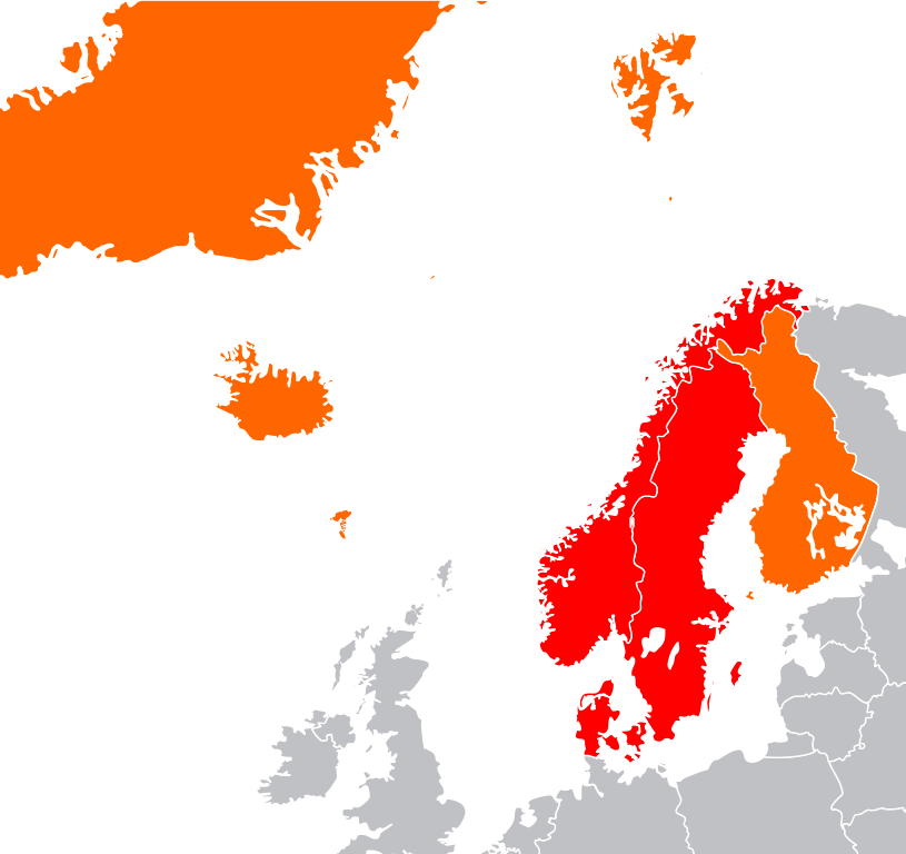
English: Map showing two of the common definitions of "Scandinavia"; a cultural, historical and ethno-linguistic region in northern Europe:
the most common usage: the three monarchies; Denmark, Norway and Sweden
an extended usage: including Finland, Iceland and the Faroe Islands
Русский: Карта показывает страны Северной Европы:
Страны Скандинавии: Дания, Норвегия и Швеция
Другие страны: Финляндия, Исландия, Гренландия и Фарерские острова |
| Petsa | (UTC) |
| Ginkuhaan | |
| Awtor |
|
| This is a retouched picture, which means that it has been digitally altered from its original version. The original can be viewed here: Location European nation states.svg:
|
I, the copyright holder of this work, hereby publish it under the following licenses:
| Ini nga file in nakalisensya ha ilarom han Creative Commons Attribution-Share Alike 3.0 Unported license. | ||
| ||
| This licensing tag was added to this file as part of the GFDL licensing update. |

|
An permiso in ginhatag ha pagkopya, pagpakalat ngan/o pagliwat hinin nga dokumento ha ilarom han mga termino han GNU Free Documentation License, Version 1.2 o mas uruurhi nga version nga ginmantala han Free Software Foundation; nga may-ada waray Invariant Sections, waray Front-Cover Texts, ngan waray Back-Cover Texts. May-ada kopya hin lisensya nga ginlalakip ha seksyon nga may-ada pamagat nga GNU Free Documentation License. |
Puydi ka pumili hin lisenysa nga karuyag mo.
Original upload log
This image is a derivative work of the following images:
- File:Location_European_nation_states.svg licensed with Cc-by-sa-3.0-migrated, GFDL
- 2010-10-09T15:55:16Z LX 2045x1720 (748293 Bytes) Reverted sockpuppet edits to version as of 15:03, 11 November 2009
- 2010-10-02T06:27:34Z Lartyo 2045x1720 (730891 Bytes) Reverted to version as of 20:37, 18 October 2009
- 2009-11-11T15:03:57Z NuclearVacuum 2045x1720 (748293 Bytes) minor
- 2009-11-11T14:59:54Z NuclearVacuum 2045x1720 (733426 Bytes) territorial fixes
- 2009-10-18T20:37:51Z NuclearVacuum 2045x1720 (730891 Bytes) several countries did not include all its territories
- 2008-12-04T00:44:42Z Ssolbergj 2045x1720 (726069 Bytes) Kosovo
- 2008-06-20T13:09:36Z Ssolbergj 2045x1720 (724181 Bytes) Reverted to version as of 00:57, 12 June 2008
- 2008-06-19T17:59:14Z Ssolbergj 2045x1720 (719110 Bytes) {{Information |Description= |Source= |Date= |Author= |Permission= |other_versions= }}
- 2008-06-12T00:57:39Z Ssolbergj 2045x1720 (724181 Bytes) {{Information |Description={{en|1=SVG map of Europe. Borders of nation states.}} {{no|1=SVG-kart over Europa. Nasjonstatlige grenser.}} |Source=[[:Image:Location Spain EU Europe 1.svg]] |Author=[[:en:User:Ssolbergj|Ssolbergj]
Uploaded with derivativeFX
Kaagi han paypay
Pidlita an adlaw/oras para makit-an an fayl nga naggawas hito nga oras.
| Pitsa/Oras | Thumbnail | Mga dimensyon | Gumaramit | Komento | |
|---|---|---|---|---|---|
| waray pa kasasapawi | 19:05, 4 Oktubre 2011 | | 1,090 × 1,027 (537 nga KB) | Pic-Sou | greenland belongs to Denmark... |
| 04:51, 10 Septyembre 2011 |  | 1,090 × 1,027 (536 nga KB) | Citypeek | Removed the text in the svg-file | |
| 16:50, 8 Septyembre 2011 |  | 1,337 × 1,025 (535 nga KB) | Citypeek | {{Information |Description={{en|1=SVG map of Europe. Borders of nation states.}} {{no|1=SVG-kart over Europa. Nasjonstatlige grenser.}} {{sv|1=SVG-karta över Europa. Europa markerat med mörkgrått. Nationsgränser dragna i vitt.}} |Source=*[[:File:Locat |
Mga Sumpay
An mga nasunod nga mga pakli nasumpay hini nga paypay:
Global file usage
An masunod nga iba nga mga wiki in nagamit hini nga file:
- Paggamit ha ar.wikipedia.org
- Paggamit ha el.wikipedia.org
- Paggamit ha en.wikipedia.org
- Paggamit ha fr.wikipedia.org
- Paggamit ha he.wikipedia.org
- Paggamit ha hy.wikipedia.org
- Paggamit ha it.wikipedia.org
- Paggamit ha ja.wikipedia.org
- Paggamit ha kab.wikipedia.org
- Paggamit ha ml.wikipedia.org
- Paggamit ha ru.wikipedia.org
- Paggamit ha sr.wikipedia.org
- Paggamit ha uk.wikipedia.org
- Paggamit ha ur.wikipedia.org
- Paggamit ha vi.wikipedia.org