Paypay:Saxony-Anhalt location map.svg

Size of this PNG preview of this SVG file: 509 × 600 nga mga pixel. Iba nga mga resolusyon: 204 × 240 nga mga pixel | 407 × 480 nga mga pixel | 652 × 768 nga mga pixel | 869 × 1,024 nga mga pixel | 1,738 × 2,048 nga mga pixel | 1,957 × 2,306 nga mga pixel.
Orihinal nga paypay (SVG nga fayl, ginbabanabanahan nga 1,957 × 2,306 nga mga pixel, kadako han fayl: 1.27 nga MB)
Dalikyat nga pulong
| Tigtulidong |
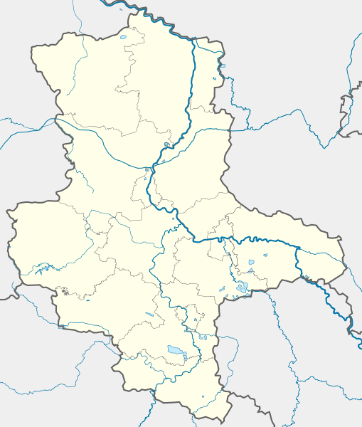
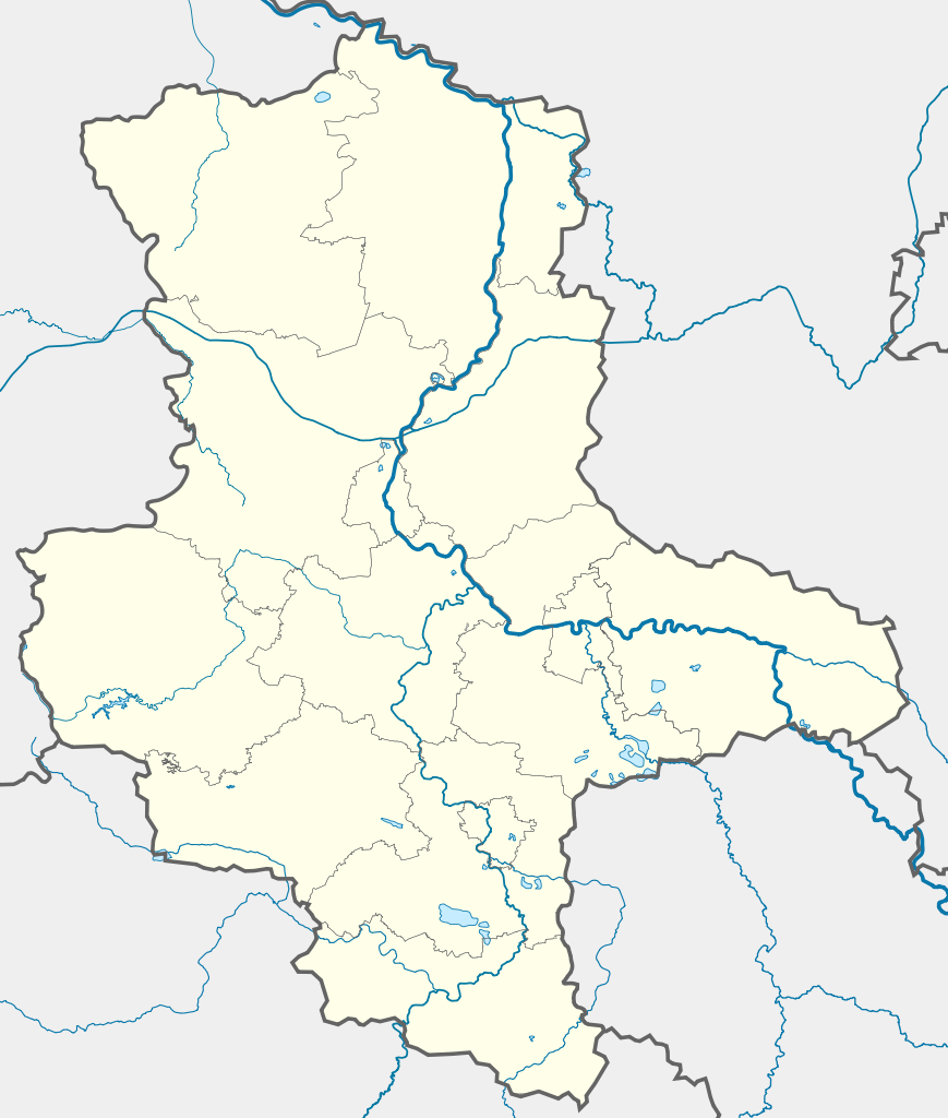
Deutsch: Positionskarte Sachsen-Anhalt, Deutschland. Geographische Begrenzung der Karte:
English: Location map Saxony-Anhalt, Germany. Geographic limits of the map:
|
| Petsa | |
| Ginkuhaan |
own work, templates |
| Awtor | TUBS |
| Other versions |
Derivative works of this file: Karte VTO 2012 under CC-by-sa.png
|

| Open this image as an overlay in Google Earth (Google Maps, Bing) | (Help|Source) |
Palilisensya:
I, the copyright holder of this work, hereby publish it under the following licenses:

|
An permiso in ginhatag ha pagkopya, pagpakalat ngan/o pagliwat hinin nga dokumento ha ilarom han mga termino han GNU Free Documentation License, Version 1.2 o mas uruurhi nga version nga ginmantala han Free Software Foundation; nga may-ada waray Invariant Sections, waray Front-Cover Texts, ngan waray Back-Cover Texts. May-ada kopya hin lisensya nga ginlalakip ha seksyon nga may-ada pamagat nga GNU Free Documentation License. |
This file is licensed under the Creative Commons Attribution-Share Alike 3.0 Unported, 2.5 Generic, 2.0 Generic and 1.0 Generic license.
- Talwas ka:
- para han pagpasaro – para han pagkopya, pagpakalat ngan pagpadangat han buhat
- para han pagremix – pag-adapt han buhat
- Ha ilarom an masunod nga mga kondisyon:
- attribution – Kinahanglanon mo tagan hin kaangayan nga credit, paghatag hin sumpay ngadto ha lisensya, ngan igbutang an imo ginbag-ohan nga binuhat. Puydi mo ini buhaton ha bisan ano nga resonable nga pamaagi, pero diri nimo pagawson nga an naghatag hin lisensya nag-eendorso ha imo o ha imo paggamit.
- share alike – Kun imo ginsagol-hin-otro, gin-iba, o gin-hingayad han buhat, ikaw in angay gud là magpakalat han imo gin-amot ha ilarom la han [http:creativecommons.org/share-your-work/licensing-considerations/compatible-licenses pareho o naangay nga lisensya] sugad han orihinal.
Puydi ka pumili hin lisenysa nga karuyag mo.
Kaagi han paypay
Pidlita an adlaw/oras para makit-an an fayl nga naggawas hito nga oras.
| Pitsa/Oras | Thumbnail | Mga dimensyon | Gumaramit | Komento | |
|---|---|---|---|---|---|
| waray pa kasasapawi | 17:14, 22 Septyembre 2009 | | 1,957 × 2,306 (1.27 nga MB) | Alexrk2 | Darstellungsreihenfolge Flüsse,Seen |
| 16:15, 22 Septyembre 2009 |  | 1,957 × 2,306 (1.26 nga MB) | Alexrk2 | Landesgrenze korr. | |
| 09:26, 2 Pebrero 2009 |  | 1,957 × 2,306 (875 nga KB) | TUBS | rivers aside district borders. +Wasserstraßenkreuz Magdeburg | |
| 01:22, 31 Enero 2009 |  | 1,957 × 2,306 (872 nga KB) | TUBS | corrected some rivers outside state of Saxony-Anhalt | |
| 22:07, 29 Enero 2009 |  | 1,957 × 2,306 (845 nga KB) | TUBS | thinner stroke weights | |
| 21:46, 29 Enero 2009 |  | 1,957 × 2,306 (845 nga KB) | TUBS | == Summary == {{Information |Description= {{de|Positionskarte Sachsen-Anhalt, Deutschland. Geographische Begrenzung der Karte:}} {{en|Location map Saxony-Anhalt, Germany. Geographic limits of the map:}} * N: |
Mga Sumpay
An mga nasunod nga mga pakli nasumpay hini nga paypay:
Global file usage
An masunod nga iba nga mga wiki in nagamit hini nga file:
- Paggamit ha ar.wikipedia.org
- Paggamit ha azb.wikipedia.org
- Paggamit ha ba.wikipedia.org
- Цербст (ҡала)
- Дессау
- Виттенберг
- Вернигероде
- Кётен
- Ильзенбург (Гарц)
- Плёцкау
- Хойккевальде
- Хакеборн
- Либехна
- Шёнебек (Эльба)
- Вольферштедт
- Кольбиц
- Фрисдорф
- Зиштедт
- Зальцмюнде
- Офельгюнне
- Коббельсдорф
- Цетлинген
- Шлагентин
- Илевиц
- Гольдшау
- Хаймбург
- Бухгольц (Альтмарк)
- Веспен (Бёрде)
- Шоллене
- Рагун
- Хельбра
- Кверфурт (Германиялағы ҡала)
- Гросмюлинген
- Веддерслебен
- Кюттен (Саксония-Анхальт)
- Хоэнтрам
- Таугвиц
- Хедерслебен (Мансфельд)
- Кальбе (Заале)
- Карсдорф
- Ауслебен
- Зоммерсдорф
- Зеебенау
- Дёбрис
- Заубах
- Хеклинген
- Цимендорф
- Турланд
- Харслебен
Kitaa durudamo nga global usage hinin nga file.