Paypay:Saltonseadrainagemap.jpg
Kadako hin nga pahiuna nga pagawas: 638 × 600 nga mga pixel. Iba nga mga resolusyon: 255 × 240 nga mga pixel | 511 × 480 nga mga pixel | 782 × 735 nga mga pixel.
Orihinal nga paypay (782 × 735 nga pixel, kadako han fayl: 278 nga KB, MIME nga tipo: image/jpeg)
Dalikyat nga pulong
| Tigtulidong |
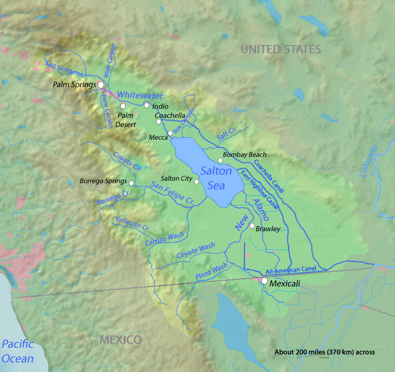
English: Map of the Salton Sea drainage area in the Salton Sink endorheic basin.
|
| Petsa | |
| Ginkuhaan | Background and river course data from http://www2.demis.nl/mapserver/mapper.asp and some topography from http://seamless.usgs.gov/website/seamless/viewer.htm |
| Awtor | Shannon |

|
This map image could be re-created using vector graphics as an SVG file. This has several advantages; see Commons:Media for cleanup for more information. If an SVG form of this image is available, please upload it and afterwards replace this template with
{{vector version available|new image name}}.
It is recommended to name the SVG file “Saltonseadrainagemap.svg”—then the template Vector version available (or Vva) does not need the new image name parameter. |


Palilisensya:
I, the copyright holder of this work, hereby publish it under the following licenses:

|
An permiso in ginhatag ha pagkopya, pagpakalat ngan/o pagliwat hinin nga dokumento ha ilarom han mga termino han GNU Free Documentation License, Version 1.2 o mas uruurhi nga version nga ginmantala han Free Software Foundation; nga may-ada waray Invariant Sections, waray Front-Cover Texts, ngan waray Back-Cover Texts. May-ada kopya hin lisensya nga ginlalakip ha seksyon nga may-ada pamagat nga GNU Free Documentation License. |
This file is licensed under the Creative Commons Attribution-Share Alike Attribution-Share Alike 4.0 International, 3.0 Unported, 2.5 Generic, 2.0 Generic and 1.0 Generic license.
- Talwas ka:
- para han pagpasaro – para han pagkopya, pagpakalat ngan pagpadangat han buhat
- para han pagremix – pag-adapt han buhat
- Ha ilarom an masunod nga mga kondisyon:
- attribution – Kinahanglanon mo tagan hin kaangayan nga credit, paghatag hin sumpay ngadto ha lisensya, ngan igbutang an imo ginbag-ohan nga binuhat. Puydi mo ini buhaton ha bisan ano nga resonable nga pamaagi, pero diri nimo pagawson nga an naghatag hin lisensya nag-eendorso ha imo o ha imo paggamit.
- share alike – Kun imo ginsagol-hin-otro, gin-iba, o gin-hingayad han buhat, ikaw in angay gud là magpakalat han imo gin-amot ha ilarom la han [http:creativecommons.org/share-your-work/licensing-considerations/compatible-licenses pareho o naangay nga lisensya] sugad han orihinal.
Puydi ka pumili hin lisenysa nga karuyag mo.
Kaagi han paypay
Pidlita an adlaw/oras para makit-an an fayl nga naggawas hito nga oras.
| Pitsa/Oras | Thumbnail | Mga dimensyon | Gumaramit | Komento | |
|---|---|---|---|---|---|
| waray pa kasasapawi | 02:37, 11 Marso 2010 | | 782 × 735 (278 nga KB) | Shannon1 | {{Information |Description={{en|1=Map of the Salton Sea drainage area, with New, Whitewater, Alamo and other rivers, as well as All-American, Coachella and East Highline Canals included}} |Source=Background and river course data from http://www2.demis.nl/ |
Mga Sumpay
An mga nasunod nga mga pakli nasumpay hini nga paypay:
Global file usage
An masunod nga iba nga mga wiki in nagamit hini nga file:
- Paggamit ha af.wikipedia.org
- Paggamit ha bg.wikipedia.org
- Paggamit ha bs.wikipedia.org
- Paggamit ha ca.wikipedia.org
- Paggamit ha ceb.wikipedia.org
- Paggamit ha cs.wikipedia.org
- Paggamit ha de.wikipedia.org
- Paggamit ha en.wikipedia.org
- Paggamit ha eo.wikipedia.org
- Paggamit ha es.wikipedia.org
- Paggamit ha fa.wikipedia.org
- Paggamit ha fi.wikipedia.org
- Paggamit ha fr.wikipedia.org
- Paggamit ha gl.wikipedia.org
- Paggamit ha he.wikipedia.org
- Paggamit ha hu.wikipedia.org
- Paggamit ha ja.wikipedia.org
- Paggamit ha nl.wikipedia.org
- Paggamit ha pl.wikipedia.org
- Paggamit ha vi.wikipedia.org
- Paggamit ha www.wikidata.org
- Paggamit ha xmf.wikipedia.org
- Paggamit ha zh.wikipedia.org