Paypay:Saarland location map 02.svg

Size of this PNG preview of this SVG file: 658 × 540 nga mga pixel. Iba nga mga resolusyon: 293 × 240 nga mga pixel | 585 × 480 nga mga pixel | 936 × 768 nga mga pixel | 1,248 × 1,024 nga mga pixel | 2,496 × 2,048 nga mga pixel.
Orihinal nga paypay (SVG nga fayl, ginbabanabanahan nga 658 × 540 nga mga pixel, kadako han fayl: 125 nga KB)
Dalikyat nga pulong
| Tigtulidong |
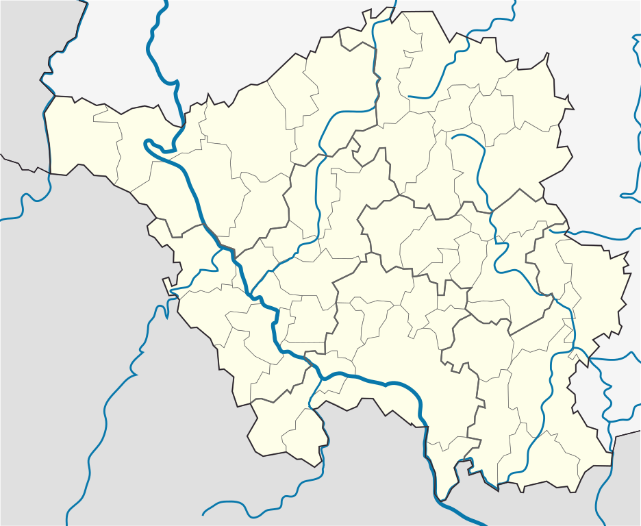
English: Position map of the state of Saarland with the six disticts and fiftytwo municipalities
Geographic limits of the map: * N: 49.65° N * S: 49.09° N * W: 6.3° E * E: 7.405° E Deutsch: Positionskarte vom Bundesland Saarland mit seinen sechs Kreisen und 52 Gemeinden Quadratische Plattkarte. Geographische Begrenzung der Karte: * N: 49.65° N * S: 49.09° N * W: 6.3° E * E: 7.405° E |
| Petsa | |
| Ginkuhaan |
Kalugaringon nga buhat, based on: |
| Awtor |
TUBS |
| Other versions |
 |
Palilisensya:
I, the copyright holder of this work, hereby publish it under the following license:
Ini nga file in nakalisensya ha ilarom han Creative Commons Attribution-Share Alike 3.0 Unported license.
- Talwas ka:
- para han pagpasaro – para han pagkopya, pagpakalat ngan pagpadangat han buhat
- para han pagremix – pag-adapt han buhat
- Ha ilarom an masunod nga mga kondisyon:
- attribution – Kinahanglanon mo tagan hin kaangayan nga credit, paghatag hin sumpay ngadto ha lisensya, ngan igbutang an imo ginbag-ohan nga binuhat. Puydi mo ini buhaton ha bisan ano nga resonable nga pamaagi, pero diri nimo pagawson nga an naghatag hin lisensya nag-eendorso ha imo o ha imo paggamit.
- share alike – Kun imo ginsagol-hin-otro, gin-iba, o gin-hingayad han buhat, ikaw in angay gud là magpakalat han imo gin-amot ha ilarom la han [http:creativecommons.org/share-your-work/licensing-considerations/compatible-licenses pareho o naangay nga lisensya] sugad han orihinal.
Kaagi han paypay
Pidlita an adlaw/oras para makit-an an fayl nga naggawas hito nga oras.
| Pitsa/Oras | Thumbnail | Mga dimensyon | Gumaramit | Komento | |
|---|---|---|---|---|---|
| waray pa kasasapawi | 15:09, 22 Marso 2010 | | 658 × 540 (125 nga KB) | TUBS | == {{int:filedesc}} == {{Information |Description={{en|1=Position map of the state of Saarland with the six disticts and fiftytwo municipalities<br> Geographic limits of the map: * N: 49.65° N * S: 49.09° N * W: 6.3° E * E: 7.405° E}} {{de|1=Positions |
Mga Sumpay
An mga nasunod nga mga pakli nasumpay hini nga paypay:
Global file usage
An masunod nga iba nga mga wiki in nagamit hini nga file:
- Paggamit ha ar.wikipedia.org
- Paggamit ha ceb.wikipedia.org
- Paggamit ha dsb.wikipedia.org
- Paggamit ha en.wikipedia.org
- Saarbrücken
- Wallerfangen
- Saarlouis
- Lebach
- Saarwellingen
- Sankt Wendel
- Heusweiler
- Überherrn
- Weiskirchen
- Homburg, Saarland
- Wadern
- Dillingen, Saarland
- Dudweiler
- Sankt Ingbert
- Merzig
- Beckingen
- Losheim am See
- Mettlach
- Perl, Saarland
- Neunkirchen, Saarland
- Ottweiler
- Eppelborn
- Illingen, Saarland
- Merchweiler
- Schiffweiler
- Spiesen-Elversberg
- Bous, Germany
- Schwalbach, Saarland
- Ensdorf, Saarland
- Nalbach
- Rehlingen-Siersburg
- Schmelz
- Wadgassen
- Friedrichsthal
- Püttlingen
- Sulzbach, Saarland
- Völklingen
- Großrosseln
- Kleinblittersdorf
- Quierschied
- Riegelsberg
- Bexbach
- Blieskastel
- Gersheim
- Kirkel
- Mandelbachtal
- Freisen
Kitaa durudamo nga global usage hinin nga file.