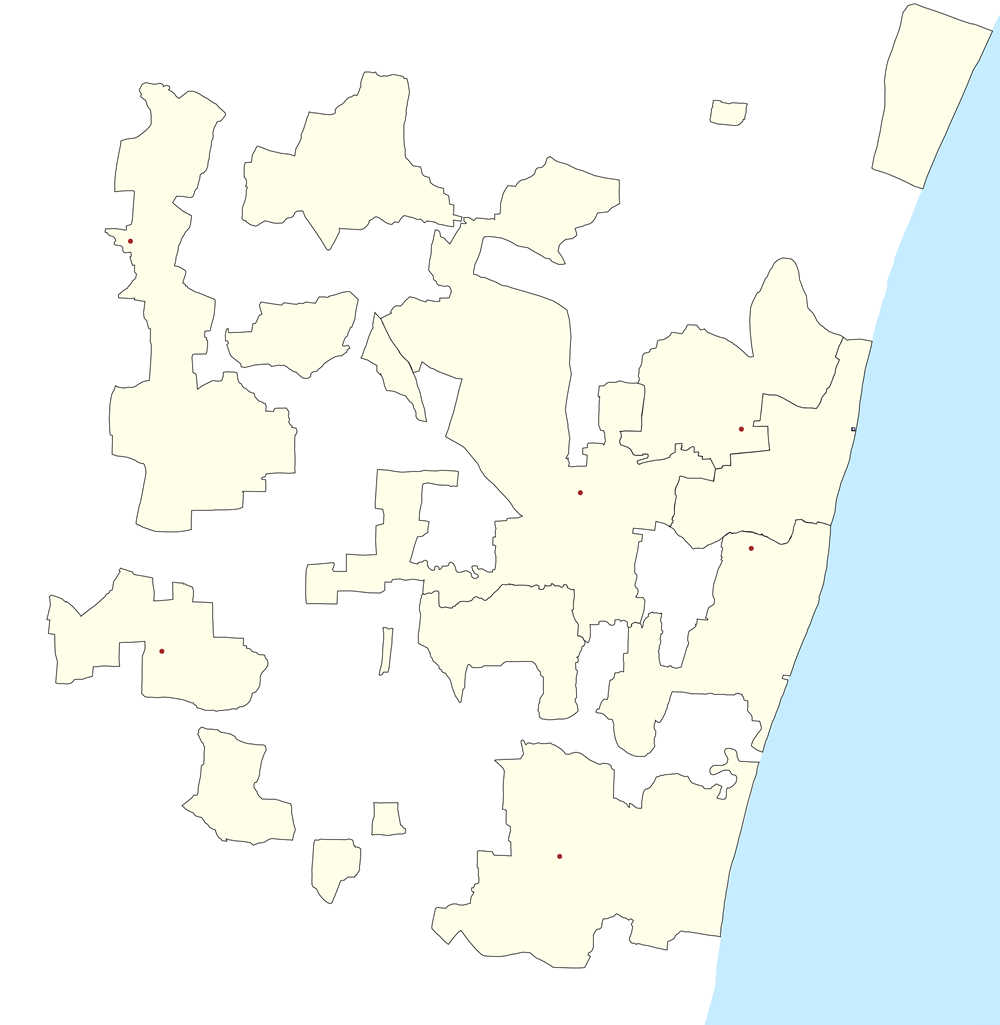
Paypay:Puducherry District Outline.png
Kadako hin nga pahiuna nga pagawas: 585 × 600 nga mga pixel. Iba nga mga resolusyon: 234 × 240 nga mga pixel | 468 × 480 nga mga pixel | 1,000 × 1,025 nga mga pixel.
Orihinal nga paypay (1,000 × 1,025 nga pixel, kadako han fayl: 163 nga KB, MIME nga tipo: image/png)
Map showing the location of the first French India Liberated Tribuvane Comnune.
Dalikyat nga pulong
| Tigtulidong |
English: Puducherry District Outline with Communes |
| Petsa | |
| Ginkuhaan | Kalugaringon nga buhat |
| Awtor | Pselvaganapathy |
Palilisensya:
I, the copyright holder of this work, hereby publish it under the following license:
Ini nga file in nakalisensya ha ilarom han Creative Commons Attribution-Share Alike 3.0 Unported license.
- Talwas ka:
- para han pagpasaro – para han pagkopya, pagpakalat ngan pagpadangat han buhat
- para han pagremix – pag-adapt han buhat
- Ha ilarom an masunod nga mga kondisyon:
- attribution – Kinahanglanon mo tagan hin kaangayan nga credit, paghatag hin sumpay ngadto ha lisensya, ngan igbutang an imo ginbag-ohan nga binuhat. Puydi mo ini buhaton ha bisan ano nga resonable nga pamaagi, pero diri nimo pagawson nga an naghatag hin lisensya nag-eendorso ha imo o ha imo paggamit.
- share alike – Kun imo ginsagol-hin-otro, gin-iba, o gin-hingayad han buhat, ikaw in angay gud là magpakalat han imo gin-amot ha ilarom la han [http:creativecommons.org/share-your-work/licensing-considerations/compatible-licenses pareho o naangay nga lisensya] sugad han orihinal.
Kaagi han paypay
Pidlita an adlaw/oras para makit-an an fayl nga naggawas hito nga oras.
| Pitsa/Oras | Thumbnail | Mga dimensyon | Gumaramit | Komento | |
|---|---|---|---|---|---|
| waray pa kasasapawi | 07:55, 25 Pebrero 2013 | | 1,000 × 1,025 (163 nga KB) | Pselvaganapathy | Stoke width increased for better map |
| 07:27, 25 Pebrero 2013 |  | 1,000 × 1,025 (149 nga KB) | Pselvaganapathy | Resize to a visible resolution (medium) | |
| 06:51, 25 Pebrero 2013 |  | 4,000 × 4,099 (633 nga KB) | Pselvaganapathy | Reverted to version as of 06:49, 25 February 2013 | |
| 06:50, 25 Pebrero 2013 |  | 4,000 × 4,099 (653 nga KB) | Pselvaganapathy | Reverted to version as of 06:38, 25 February 2013 | |
| 06:49, 25 Pebrero 2013 |  | 4,000 × 4,099 (633 nga KB) | Pselvaganapathy | Changed Colors | |
| 06:38, 25 Pebrero 2013 |  | 4,000 × 4,099 (653 nga KB) | Pselvaganapathy | Color changes in Map | |
| 17:13, 23 Pebrero 2013 |  | 4,000 × 4,099 (672 nga KB) | Pselvaganapathy | User created page with UploadWizard |
Mga Sumpay
An mga nasunod nga mga pakli nasumpay hini nga paypay:
Global file usage
An masunod nga iba nga mga wiki in nagamit hini nga file:
- Paggamit ha ar.wikipedia.org
- Paggamit ha azb.wikipedia.org
- ویرامپاتینام
- کادووانور
- مانقالام, پودوچری
- ماناپاتو
- مانامدو
- ماناکوپام
- مادوکارای
- آبیشقاپاکام
- سمبیاپالایام
- سلیامدو
- پودوکوپام, باهور
- پورنانکوپام
- پیلاییارکوپام, باهور
- پاریکالپاتو
- پانیتیتو
- پانداسوژانالور
- پانایادیکوپام
- نونانکوپام
- امبالام
- ایریپاکام
- چینا کاراییامپوتور
- نالاوادو
- مورتیکوپام
- آرانقانور
- سورییانکوپام
- سورامانقالام
- کیژور, پودوچری
- آندیارپالایام
- کیرومامپاکام
- کودییروپوپالایام
- کورکادو
- کاراییامپوتور
- کوروویناتام
- کاریکالامپاکام
- کارییامانیکام
- تاوالاکوپام
- کالمانداپام
- تیمانایاکانپالایام
- کریشناوارام, پودوچری
- باهور (دوغو)
- Paggamit ha bh.wikipedia.org
- Paggamit ha bn.wikipedia.org
- Paggamit ha ceb.wikipedia.org
- Paggamit ha el.wikipedia.org
- Paggamit ha en.wikipedia.org
Kitaa durudamo nga global usage hinin nga file.