Paypay:Nseamap.gif
Waray mas hiruhitaas nga resolusyon.
Nseamap.gif (280 × 374 nga pixel, kadako han fayl: 43 nga KB, MIME nga tipo: image/gif)
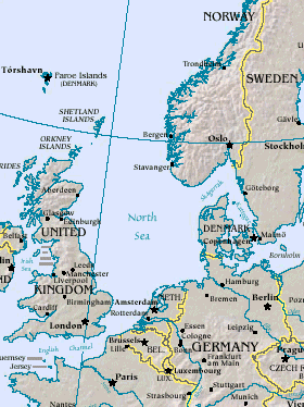
Map of North Sea, from the US Department of Energy: http://eia.doe.gov/emeu/cabs/northsea.html
Русский: Северное море
| This image is a work of a United States Department of Energy (or predecessor organization) employee, taken or made as part of that person's official duties. As a work of the U.S. federal government, the image is in the public domain.
Please note that national laboratories operate under varying licences and some are not free. Check the site policies of any national lab before crediting it with this tag.
|

|
Kaagi han paypay
Pidlita an adlaw/oras para makit-an an fayl nga naggawas hito nga oras.
| Pitsa/Oras | Thumbnail | Mga dimensyon | Gumaramit | Komento | |
|---|---|---|---|---|---|
| waray pa kasasapawi | 14:20, 26 Marso 2005 | | 280 × 374 (43 nga KB) | Ivan~commonswiki | Map of North Sea, from the en:US Department of Energy: [http://eia.doe.gov/emeu/cabs/northsea.html http://eia.doe.gov/emeu/cabs/northsea.html] {{PD-USGov}} |
Mga Sumpay
An mga nasunod nga mga pakli nasumpay hini nga paypay:
Global file usage
An masunod nga iba nga mga wiki in nagamit hini nga file:
- Paggamit ha als.wikipedia.org
- Paggamit ha am.wikipedia.org
- Paggamit ha ast.wikipedia.org
- Paggamit ha as.wikipedia.org
- Paggamit ha ban.wikipedia.org
- Paggamit ha ba.wikipedia.org
- Paggamit ha be-tarask.wikipedia.org
- Paggamit ha csb.wikipedia.org
- Paggamit ha cv.wikipedia.org
- Paggamit ha da.wikipedia.org
- Paggamit ha de.wiktionary.org
- Paggamit ha diq.wikipedia.org
- Paggamit ha en.wikipedia.org
- Paggamit ha eo.wikipedia.org
- Paggamit ha gl.wikipedia.org
- Paggamit ha he.wikipedia.org
- Paggamit ha hif.wikipedia.org
- Paggamit ha hr.wikipedia.org
- Paggamit ha hu.wiktionary.org
- Paggamit ha id.wikipedia.org
- Paggamit ha is.wikipedia.org
- Paggamit ha it.wikipedia.org
- Paggamit ha it.wikibooks.org
- Paggamit ha ja.wikipedia.org
- Paggamit ha jv.wikipedia.org
- Paggamit ha ka.wikipedia.org
- Paggamit ha kw.wikipedia.org
- Paggamit ha lij.wikipedia.org
- Paggamit ha lt.wikipedia.org
- Paggamit ha ml.wikipedia.org
- Paggamit ha mn.wikipedia.org
- Paggamit ha mwl.wikipedia.org
- Paggamit ha nn.wikipedia.org
- Paggamit ha olo.wikipedia.org
- Paggamit ha pl.wiktionary.org
- Paggamit ha pt.wikipedia.org
- Paggamit ha roa-tara.wikipedia.org
- Paggamit ha ru.wikipedia.org
- Paggamit ha ru.wiktionary.org
- Paggamit ha sah.wikipedia.org
- Paggamit ha sco.wikipedia.org
- Paggamit ha simple.wikipedia.org
Kitaa durudamo nga global usage hinin nga file.