Paypay:NEO lake jau big.jpg

Kadako hin nga pahiuna nga pagawas: 600 × 600 nga mga pixel. Iba nga mga resolusyon: 240 × 240 nga mga pixel | 480 × 480 nga mga pixel | 750 × 750 nga mga pixel.
Orihinal nga paypay (750 × 750 nga pixel, kadako han fayl: 134 nga KB, MIME nga tipo: image/jpeg)
Dalikyat nga pulong
| Tigtulidong |
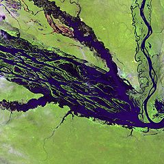
English: The Negro River flowing through the eastern edge of Brazil’s Jau National Park. The river is the big strip of blue running from left to right across the image, and the other blue ribbons are tributaries. Originating at the border of Venezuela and Brazil, the Negro River meets up with the Amazon in central Brazil to become its largest tributary. Half-submerged islands can be seen in the center of the river. Between November and April when the river is at its peak, many of these islands disappear. |
| Petsa | |
| Ginkuhaan |
http://earthobservatory.nasa.gov/Newsroom/NewImages/images.php3?img_id=10843
|
| Awtor | NASA and USGS EROS Data Center Satellite Systems Branch |
Palilisensya:
This image is in the public domain in the United States because it only contains materials that originally came from the United States Geological Survey, an agency of the United States Department of the Interior. For more information, see the official USGS copyright policy.
|
Original upload log
The original description page was here. All following user names refer to en.wikipedia.
- 2003-11-23 05:55 Snoyes 750×750×8 (136760 bytes)
Kaagi han paypay
Pidlita an adlaw/oras para makit-an an fayl nga naggawas hito nga oras.
| Pitsa/Oras | Thumbnail | Mga dimensyon | Gumaramit | Komento | |
|---|---|---|---|---|---|
| waray pa kasasapawi | 20:27, 4 Abril 2008 | | 750 × 750 (134 nga KB) | File Upload Bot (Magnus Manske) | {{BotMoveToCommons|en.wikipedia}} {{Information |Description={{en|'''Credit(s):''' [http://edc.usgs.gov/ USGS EROS Data Center] Satellite Systems Branch. '''Source:''' http://earthobservatory.nasa.gov/Newsroom/NewImages/images.php3?img_id=10843 ''?The |
Mga Sumpay
An mga nasunod nga mga pakli nasumpay hini nga paypay:
Global file usage
An masunod nga iba nga mga wiki in nagamit hini nga file:
- Paggamit ha ar.wikipedia.org
- Paggamit ha ast.wikipedia.org
- Paggamit ha ba.wikipedia.org
- Paggamit ha be.wikipedia.org
- Paggamit ha bg.wikipedia.org
- Paggamit ha ca.wikipedia.org
- Paggamit ha de.wikipedia.org
- Paggamit ha de.wikivoyage.org
- Paggamit ha en.wikipedia.org
- Paggamit ha es.wikipedia.org
- Paggamit ha eu.wikipedia.org
- Paggamit ha fr.wikipedia.org
- Paggamit ha he.wikipedia.org
- Paggamit ha he.wikivoyage.org
- Paggamit ha hi.wikipedia.org
- Paggamit ha hr.wikipedia.org
- Paggamit ha id.wikipedia.org
- Paggamit ha it.wikivoyage.org
- Paggamit ha ja.wikipedia.org
- Paggamit ha ka.wikipedia.org
- Paggamit ha ko.wikipedia.org
- Paggamit ha lt.wikipedia.org
- Paggamit ha mai.wikipedia.org
- Paggamit ha ml.wikipedia.org
- Paggamit ha mt.wikipedia.org
- Paggamit ha ne.wikipedia.org
- Paggamit ha nl.wikipedia.org
- Paggamit ha pl.wikipedia.org
Kitaa durudamo nga global usage hinin nga file.