Paypay:Munnar Top station.jpg

Kadako hin nga pahiuna nga pagawas: 800 × 494 nga mga pixel. Iba nga mga resolusyon: 320 × 197 nga mga pixel | 640 × 395 nga mga pixel | 1,024 × 632 nga mga pixel | 1,246 × 769 nga mga pixel.
Orihinal nga paypay (1,246 × 769 nga pixel, kadako han fayl: 905 nga KB, MIME nga tipo: image/jpeg)
Dalikyat nga pulong
| Tigtulidong |
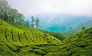
English: Top station, 41 km (1hr) from Munnar is aptly named, as it is home to some of the highest tea plantations in India. It lies on the state border between Kerala and Tamilnadu and commands a panoramic view of rolling green hills. |
||
| Petsa | |||
| Ginkuhaan | Top Station - Munnar | ||
| Awtor | Bimal K C from Cochin, India | ||
| Pagtugot (Gin-uutro paggamit inin nga file) |
This file is licensed under the Creative Commons Attribution 2.0 Generic license.
|
|
Kaagi han paypay
Pidlita an adlaw/oras para makit-an an fayl nga naggawas hito nga oras.
| Pitsa/Oras | Thumbnail | Mga dimensyon | Gumaramit | Komento | |
|---|---|---|---|---|---|
| waray pa kasasapawi | 13:05, 6 Abril 2011 | | 1,246 × 769 (905 nga KB) | Ras67 | cropped |
| 12:03, 12 Agosto 2008 |  | 1,280 × 803 (952 nga KB) | Challiyan | {{Information |Description= Top station, 41 km (1hr) from Munnar is aptly named, as it is home to some of the highest tea plantations in India. It lies on the state border between Kerala and Tamilnadu and commands a panoramic view of rolling green hills. |
Mga Sumpay
An mga nasunod nga mga pakli nasumpay hini nga paypay:
Global file usage
An masunod nga iba nga mga wiki in nagamit hini nga file:
- Paggamit ha bo.wikipedia.org
- Paggamit ha cs.wikipedia.org
- Paggamit ha de.wikipedia.org
- Paggamit ha en.wikipedia.org
- Paggamit ha en.wikivoyage.org
- Paggamit ha es.wikipedia.org
- Paggamit ha fr.wikipedia.org
- Paggamit ha gu.wikipedia.org
- Paggamit ha id.wikipedia.org
- Paggamit ha incubator.wikimedia.org
- Paggamit ha kn.wikipedia.org
- Paggamit ha ml.wikipedia.org
- കേരളം
- മൂന്നാർ
- വിക്കിപീഡിയ:തിരഞ്ഞെടുക്കാവുന്ന ചിത്രങ്ങൾ/നിലവറ 19
- വിക്കിപീഡിയ:തിരഞ്ഞെടുത്ത ചിത്രങ്ങൾ/മേയ് 2016
- വിക്കിപീഡിയ:തിരഞ്ഞെടുത്ത ചിത്രങ്ങൾ/08-05-2016
- വിക്കിപീഡിയ:തിരഞ്ഞെടുത്ത ചിത്രങ്ങൾ/09-05-2016
- വിക്കിപീഡിയ:തിരഞ്ഞെടുത്ത ചിത്രങ്ങൾ/10-05-2016
- വിക്കിപീഡിയ:തിരഞ്ഞെടുത്ത ചിത്രങ്ങൾ/11-05-2016
- വിക്കിപീഡിയ:തിരഞ്ഞെടുത്ത ചിത്രങ്ങൾ/12-05-2016
- വിക്കിപീഡിയ:തിരഞ്ഞെടുത്ത ചിത്രങ്ങൾ/13-05-2016
- വിക്കിപീഡിയ:തിരഞ്ഞെടുത്ത ചിത്രങ്ങൾ/14-05-2016
- Paggamit ha nl.wikipedia.org
- Paggamit ha no.wiktionary.org
- Paggamit ha pl.wikipedia.org
- Paggamit ha ru.wikipedia.org
- Paggamit ha sa.wikipedia.org
- Paggamit ha sv.wikipedia.org
- Paggamit ha ta.wikipedia.org
- Paggamit ha te.wikipedia.org
- Paggamit ha ur.wikipedia.org