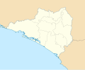
Paypay:Mexico Colima location map.svg

Size of this PNG preview of this SVG file: 512 × 389 nga mga pixel. Iba nga mga resolusyon: 316 × 240 nga mga pixel | 632 × 480 nga mga pixel | 1,011 × 768 nga mga pixel | 1,280 × 973 nga mga pixel | 2,560 × 1,945 nga mga pixel.
Orihinal nga paypay (SVG nga fayl, ginbabanabanahan nga 512 × 389 nga mga pixel, kadako han fayl: 755 nga KB)
Kaagi han paypay
Pidlita an adlaw/oras para makit-an an fayl nga naggawas hito nga oras.
| Pitsa/Oras | Thumbnail | Mga dimensyon | Gumaramit | Komento | |
|---|---|---|---|---|---|
| waray pa kasasapawi | 14:46, 5 Hunyo 2016 |  | 512 × 389 (755 nga KB) | Addicted04 | Borders |
| 13:43, 5 Hunyo 2016 |  | 512 × 389 (756 nga KB) | Addicted04 | New map. N:19.6, S:18.6, E:-103.4, W:-104.8 | |
| 19:25, 7 Agosto 2011 |  | 799 × 664 (212 nga KB) | Battroid | {{Information |Description={{es|1=Trabajo propio a partir del mapa de municipios del INEGI y costas tomadas de OpenStreetMap.org (bajo licencia Creative Commons Attribution-Share Alike 2.0 Generic). Límites del mapa: * Oeste : 104º 7' O * Este : 103� | |
| 22:15, 4 Enero 2011 |  | 799 × 664 (212 nga KB) | Addicted04 | Costa oeste | |
| 21:15, 27 Oktubre 2009 |  | 799 × 664 (222 nga KB) | Spischot | {{Information |Description={{es|1=Trabajo propio a partir del mapa de municipios del INEGI y costas tomadas de OpenStreetMap.org (bajo licencia Creative Commons Attribution-Share Alike 2.0 Generic). Límites del mapa: * Oeste : 104º 7' O * Este : 103� |
Mga Sumpay
An mga nasunod nga mga pakli nasumpay hini nga paypay:
Global file usage
An masunod nga iba nga mga wiki in nagamit hini nga file:
- Paggamit ha ar.wikipedia.org
- Paggamit ha ba.wikipedia.org
- Paggamit ha bg.wikipedia.org
- Paggamit ha ceb.wikipedia.org
- Paggamit ha ce.wikipedia.org
- Paggamit ha cs.wikipedia.org
- Paggamit ha de.wikipedia.org
- Paggamit ha en.wikipedia.org
- Colima (city)
- Manzanillo, Colima
- Tecomán
- Comala
- Playa de Oro International Airport
- Colima Airport
- Villa de Álvarez
- Ixtlahuacán
- Minatitlán, Colima
- Coquimatlán
- Module:Location map/data/Mexico Colima/doc
- User:Ty654/List of earthquakes exceeding magnitude 8+
- User:Ty654/List of earthquakes from 1900-1949 exceeding magnitude 7+
- Module:Location map/data/Mexico Colima
- User:Ty654/List of earthquakes from 2000-present exceeding magnitude 7+
- User:Ty654/List of earthquakes from 1930-1939 exceeding magnitude 6+
- User:Ty654/List of earthquakes from 1995-1999 exceeding magnitude 6+
- User:Ty654/List of earthquakes from 2000-2004 exceeding magnitude 6+
- La Yerbabuena, Comala
- Paggamit ha eo.wikipedia.org
- Paggamit ha es.wikipedia.org
- Paggamit ha fa.wikipedia.org
- Paggamit ha fr.wikipedia.org
- Paggamit ha he.wikipedia.org
Kitaa durudamo nga global usage hinin nga file.
