Paypay:Marianatrenchmap.png

Kadako hin nga pahiuna nga pagawas: 460 × 599 nga mga pixel. Iba nga mga resolusyon: 184 × 240 nga mga pixel | 369 × 480 nga mga pixel | 756 × 984 nga mga pixel.
Orihinal nga paypay (756 × 984 nga pixel, kadako han fayl: 758 nga KB, MIME nga tipo: image/png)
This is a picture of what it looks like from a satellite perspective.
Dalikyat nga pulong
| Tigtulidong |
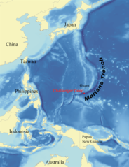
English: Map showing the location of the Mariana Trench, designed as a replacement for en:Image:Mariana_trench_location.jpg. Français : Carte montrant la position de la fosse des Mariannes.
Latina: Haec charta locum Fossae Marianae demonstrat. |
| Petsa | |
| Ginkuhaan | self-made using data from NOAA[dead link]. |
| Awtor | wallace |
Palilisensya:
I, Kmusser, the copyright holder of this work, hereby publishes it under the following licenses:

|
An permiso in ginhatag ha pagkopya, pagpakalat ngan/o pagliwat hinin nga dokumento ha ilarom han mga termino han GNU Free Documentation License, Version 1.2 o mas uruurhi nga version nga ginmantala han Free Software Foundation; nga may-ada waray Invariant Sections, waray Front-Cover Texts, ngan waray Back-Cover Texts. May-ada kopya hin lisensya nga ginlalakip ha seksyon nga may-ada pamagat nga GNU Free Documentation License. |
| Ini nga file in nakalisensya ha ilarom han Creative Commons Attribution-Share Alike 3.0 Unported license. | ||
| Attribution: I, Kmusser | ||
| ||
| This licensing tag was added to this file as part of the GFDL licensing update. |
This file is licensed under the Creative Commons Attribution 2.5 Generic license.
Attribution: I, Kmusser
- Talwas ka:
- para han pagpasaro – para han pagkopya, pagpakalat ngan pagpadangat han buhat
- para han pagremix – pag-adapt han buhat
- Ha ilarom an masunod nga mga kondisyon:
- attribution – Kinahanglanon mo tagan hin kaangayan nga credit, paghatag hin sumpay ngadto ha lisensya, ngan igbutang an imo ginbag-ohan nga binuhat. Puydi mo ini buhaton ha bisan ano nga resonable nga pamaagi, pero diri nimo pagawson nga an naghatag hin lisensya nag-eendorso ha imo o ha imo paggamit.
Puydi ka pumili hin lisenysa nga karuyag mo.
Kaagi han paypay
Pidlita an adlaw/oras para makit-an an fayl nga naggawas hito nga oras.
| Pitsa/Oras | Thumbnail | Mga dimensyon | Gumaramit | Komento | |
|---|---|---|---|---|---|
| waray pa kasasapawi | 21:39, 14 Hunyo 2020 | | 756 × 984 (758 nga KB) | Roy17 | lossless crop from 2007 original, then annotated |
| 08:43, 2 Hunyo 2016 |  | 756 × 985 (604 nga KB) | McGeddon | Cropped 1 % horizontally and < 1 % vertically using CropTool with precise mode. Crop out 1px black border. | |
| 06:09, 8 Enero 2008 |  | 761 × 989 (598 nga KB) | Lee Carre | File size efficiency, reduced my 50KB without loss of image data. | |
| 15:26, 2 Agosto 2007 |  | 773 × 1,000 (658 nga KB) | Kmusser | {{Information |Description=Map showing the location of the Mariana Trench, designed as a replacement for en:Image:Mariana_trench_location.jpg. |Source=self-made using [http://www.ngdc.noaa.gov/seg/fliers/se-1104.shtml|data from |
Mga Sumpay
An mga nasunod nga mga pakli nasumpay hini nga paypay:
Global file usage
An masunod nga iba nga mga wiki in nagamit hini nga file:
- Paggamit ha af.wikipedia.org
- Paggamit ha ar.wikipedia.org
- Paggamit ha ary.wikipedia.org
- Paggamit ha ast.wikipedia.org
- Paggamit ha azb.wikipedia.org
- Paggamit ha az.wikipedia.org
- Paggamit ha ba.wikipedia.org
- Paggamit ha be-tarask.wikipedia.org
- Paggamit ha be.wikipedia.org
- Paggamit ha bg.wikipedia.org
- Paggamit ha bn.wikipedia.org
- Paggamit ha br.wikipedia.org
- Paggamit ha bs.wikipedia.org
- Paggamit ha ca.wikipedia.org
- Paggamit ha ceb.wikipedia.org
- Paggamit ha ce.wikipedia.org
- Paggamit ha ckb.wikipedia.org
- Paggamit ha cs.wikipedia.org
- Paggamit ha da.wikipedia.org
- Paggamit ha el.wikipedia.org
- Paggamit ha en.wikipedia.org
- Challenger Deep
- Mariana Trench
- Abyssal plain
- Kaikō ROV
- User:Kmusser/Images
- Portal:Geology
- Nereus (underwater vehicle)
- Marianas Trench Marine National Monument
- Deep-sea community
- Wikipedia:ITN archives/2009/June
- User:DiverDave/Deep sea communities
- List of submarine topographical features
- User:سائغ/T
- Hadal zone microbial communities
- Paggamit ha en.wikibooks.org
- Paggamit ha en.wikinews.org
- Paggamit ha eo.wikipedia.org
- Paggamit ha es.wikipedia.org
Kitaa durudamo nga global usage hinin nga file.