Paypay:LocationMontserrat.png
Waray mas hiruhitaas nga resolusyon.
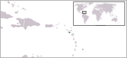
LocationMontserrat.png (250 × 115 nga pixel, kadako han fayl: 8 nga KB, MIME nga tipo: image/png)
Location map for Montserrat.
Originally created for English Wikipedia by Vardion.
| |
This work has been released into the public domain by its author, Vardion, at the English Wikipedia project. This applies worldwide. In case this is not legally possible: |
Kaagi han paypay
Pidlita an adlaw/oras para makit-an an fayl nga naggawas hito nga oras.
| Pitsa/Oras | Thumbnail | Mga dimensyon | Gumaramit | Komento | |
|---|---|---|---|---|---|
| waray pa kasasapawi | 17:04, 27 Disyembre 2004 | | 250 × 115 (8 nga KB) | EugeneZelenko | Location map for the Montserrat.<br/>Originally created for English Wikipedia by Vardion.<br/>{{PD}}<br/>Category:Country locator maps |
Mga Sumpay
An mga nasunod nga mga pakli nasumpay hini nga paypay:
Global file usage
An masunod nga iba nga mga wiki in nagamit hini nga file:
- Paggamit ha ar.wikipedia.org
- Paggamit ha be-tarask.wikipedia.org
- Paggamit ha be.wikipedia.org
- Paggamit ha bg.wikipedia.org
- Paggamit ha bpy.wikipedia.org
- Paggamit ha bs.wikipedia.org
- Paggamit ha ceb.wikipedia.org
- Paggamit ha el.wikipedia.org
- Paggamit ha en.wikipedia.org
- Paggamit ha en.wikivoyage.org
- Paggamit ha eo.wikipedia.org
- Paggamit ha frp.wikipedia.org
- Paggamit ha fr.wikipedia.org
- Paggamit ha gcr.wikipedia.org
- Paggamit ha he.wikivoyage.org
- Paggamit ha hr.wikipedia.org
- Paggamit ha hu.wikipedia.org
- Paggamit ha hy.wikipedia.org
- Paggamit ha jam.wikipedia.org
- Paggamit ha ja.wikipedia.org
- Paggamit ha jv.wikipedia.org
- Paggamit ha ka.wikipedia.org
- Paggamit ha ko.wikipedia.org
- Paggamit ha ko.wiktionary.org
- Paggamit ha kw.wikipedia.org
- Paggamit ha ky.wikipedia.org
- Paggamit ha lij.wikipedia.org
- Paggamit ha li.wikipedia.org
- Paggamit ha lmo.wikipedia.org
- Paggamit ha lt.wiktionary.org
- Paggamit ha mrj.wikipedia.org
- Paggamit ha mr.wikipedia.org
- Paggamit ha ms.wikipedia.org
- Paggamit ha nl.wikipedia.org
- Paggamit ha nn.wikipedia.org
- Paggamit ha nov.wikipedia.org
- Paggamit ha no.wikipedia.org
- Paggamit ha oc.wikipedia.org
- Paggamit ha pcd.wikipedia.org
- Paggamit ha pl.wikipedia.org
Kitaa durudamo nga global usage hinin nga file.