Paypay:Kingdoms around Israel 830 map.svg

Size of this PNG preview of this SVG file: 502 × 599 nga mga pixel. Iba nga mga resolusyon: 201 × 240 nga mga pixel | 402 × 480 nga mga pixel | 644 × 768 nga mga pixel | 858 × 1,024 nga mga pixel | 1,717 × 2,048 nga mga pixel | 720 × 859 nga mga pixel.
Orihinal nga paypay (SVG nga fayl, ginbabanabanahan nga 720 × 859 nga mga pixel, kadako han fayl: 122 nga KB)
| Tigtulidong |
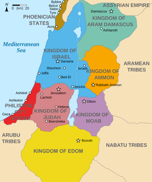
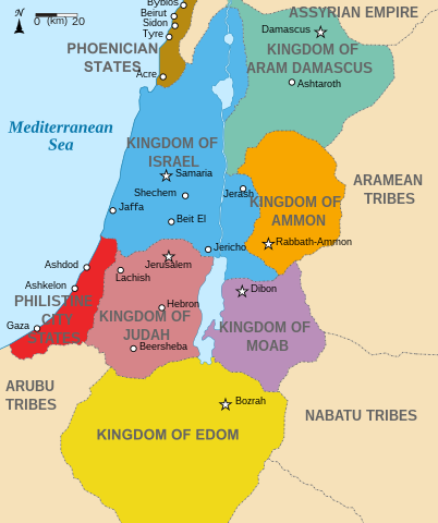
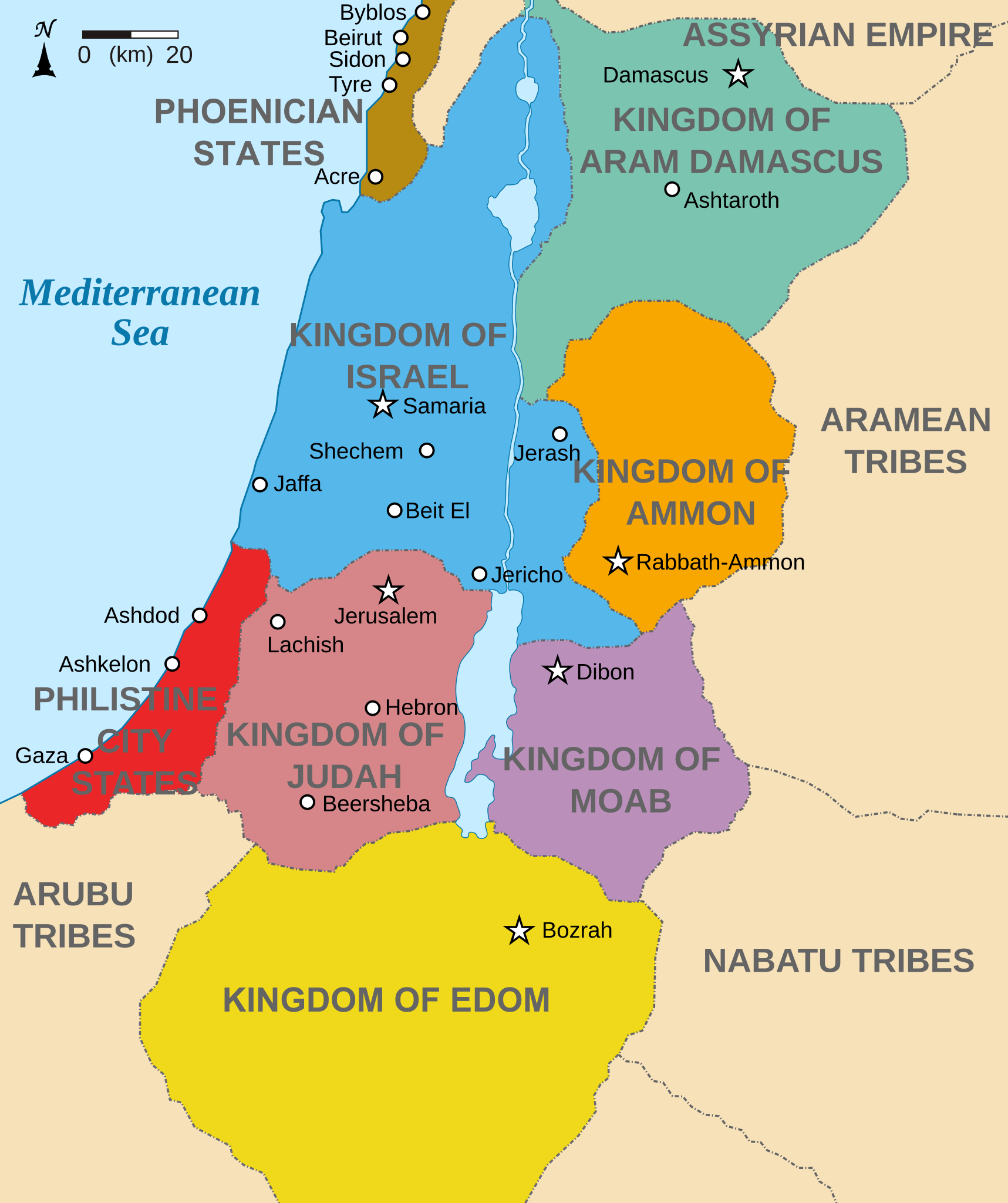
English: Map showing states around Israel & Judah. The Kingdoms around Israel & Judah are colored:
|
| Petsa | (UTC) |
| Ginkuhaan | |
| Awtor |
|
| Other versions |
[]
|


I, the copyright holder of this work, hereby publish it under the following licenses:
Ini nga file in nakalisensya ha ilarom han Creative Commons Attribution-Share Alike 3.0 Unported license.
- Talwas ka:
- para han pagpasaro – para han pagkopya, pagpakalat ngan pagpadangat han buhat
- para han pagremix – pag-adapt han buhat
- Ha ilarom an masunod nga mga kondisyon:
- attribution – Kinahanglanon mo tagan hin kaangayan nga credit, paghatag hin sumpay ngadto ha lisensya, ngan igbutang an imo ginbag-ohan nga binuhat. Puydi mo ini buhaton ha bisan ano nga resonable nga pamaagi, pero diri nimo pagawson nga an naghatag hin lisensya nag-eendorso ha imo o ha imo paggamit.
- share alike – Kun imo ginsagol-hin-otro, gin-iba, o gin-hingayad han buhat, ikaw in angay gud là magpakalat han imo gin-amot ha ilarom la han [http:creativecommons.org/share-your-work/licensing-considerations/compatible-licenses pareho o naangay nga lisensya] sugad han orihinal.

|
An permiso in ginhatag ha pagkopya, pagpakalat ngan/o pagliwat hinin nga dokumento ha ilarom han mga termino han GNU Free Documentation License, Version 1.2 o mas uruurhi nga version nga ginmantala han Free Software Foundation; nga may-ada waray Invariant Sections, waray Front-Cover Texts, ngan waray Back-Cover Texts. May-ada kopya hin lisensya nga ginlalakip ha seksyon nga may-ada pamagat nga GNU Free Documentation License. |
Puydi ka pumili hin lisenysa nga karuyag mo.
Original upload log
This image is a derivative work of the following images:
- File:Kingdoms_of_Israel_and_Judah_map_830.svg licensed with Cc-by-sa-3.0, GFDL
- 2010-07-13T10:51:49Z Richardprins 720x859 (80858 Bytes) Added colors for the two kingdoms and converted their text to path and arial
- 2010-07-12T23:53:35Z Richardprins 720x859 (63843 Bytes) Shrinked down the borders
- 2010-07-12T19:43:31Z Richardprins 720x859 (63800 Bytes) {{Information |Description={{en|1=Map showing the ancient levant borders and ancient cities such as [[Urmomium]] and [[Jerash]]. The map also shows the region in the 9th century BCE. Notice the coastal land of Philistia, from
Uploaded with derivativeFX
Kaagi han paypay
Pidlita an adlaw/oras para makit-an an fayl nga naggawas hito nga oras.
| Pitsa/Oras | Thumbnail | Mga dimensyon | Gumaramit | Komento | |
|---|---|---|---|---|---|
| waray pa kasasapawi | 15:32, 29 Oktubre 2022 | | 720 × 859 (122 nga KB) | Muchado | Fixing font problems (hopefully) |
| 15:11, 29 Oktubre 2022 |  | 720 × 859 (283 nga KB) | Muchado | Added "Philistine City States" which was unintentionally missed off... | |
| 15:06, 29 Oktubre 2022 |  | 720 × 859 (239 nga KB) | Muchado | Coloured states, removed anachronistic Petra, added Bozrah, removed Urmomium (Your mom...!), edited Arabu to Arubu, edited to Philistine City States | |
| 15:51, 10 Pebrero 2017 |  | 720 × 859 (167 nga KB) | Malus Catulus | Removed 'Sizu' - a weird artifact from the Norse original | |
| 12:58, 13 Hulyo 2010 |  | 720 × 859 (165 nga KB) | Malus Catulus | livened up the colors, converted med sea text to path | |
| 11:26, 13 Hulyo 2010 |  | 720 × 859 (139 nga KB) | Malus Catulus | {{Information |Description={{en|1=Map showing the ancient levant borders and ancient cities such as Urmomium and Jerash. The Kingdoms around Israel and Judah are colored. The map also shows the region in the 9th century BCE. Notice the coastal lan |
Mga Sumpay
Global file usage
An masunod nga iba nga mga wiki in nagamit hini nga file:
- Paggamit ha af.wikipedia.org
- Paggamit ha arc.wikipedia.org
- Paggamit ha ar.wikipedia.org
- Paggamit ha arz.wikipedia.org
- Paggamit ha azb.wikipedia.org
- Paggamit ha bg.wikipedia.org
- Paggamit ha bn.wikipedia.org
- Paggamit ha br.wikipedia.org
- Paggamit ha ca.wikipedia.org
- Paggamit ha cs.wikipedia.org
- Paggamit ha da.wikipedia.org
- Paggamit ha en.wikipedia.org
- Ammon
- History of the ancient Levant
- Kingdom of Judah
- Kingdom of Israel (Samaria)
- Philistines
- Moab
- Philistia
- Talk:Phoenician language
- Aram-Damascus
- Edom
- Portal:Bible/Featured chapter/Psalms
- Portal:Bible/Featured chapter/Psalms 83
- User:Kazkaskazkasako/Books/History
- Transjordan (region)
- Ezekiel 25
- User:Falcaorib
- User:Jacksonmcdonald3425/sandbox
- Paggamit ha en.wiktionary.org
- Paggamit ha eo.wikipedia.org
- Paggamit ha et.wikipedia.org
- Paggamit ha eu.wikipedia.org
Kitaa durudamo nga global usage hinin nga file.