Orihinal nga paypay(SVG nga fayl, ginbabanabanahan nga 2,020 × 3,140 nga mga pixel, kadako han fayl: 289 nga KB)

An fayl in tikang ha Wikimedia Commons ngan puydi mahigamitan para han iba nga mga proyekto. An paglaladawan han iya fayl han paglaladawan nga pakli didto in ginpapakita ha sirong.

Image of the year
Image of the year
Featured image

Wikimedia Commons

This file was a candidate in Picture of the Year 2007.
This is a featured picture on Wikimedia Commons (Featured pictures) and is considered one of the finest images. See its nomination here.

If you have an image of similar quality that can be published under a suitable copyright license, be sure to upload it, tag it, and nominate it.

Dalikyat nga pulong

Camera location36° 08′ 00″ N, 5° 21′ 00″ W Kartographer map based on OpenStreetMap.View this and other nearby images on: OpenStreetMapinfo
Tigtulidong
Čeština: Mapa ostrova Gibraltar v angličtině.
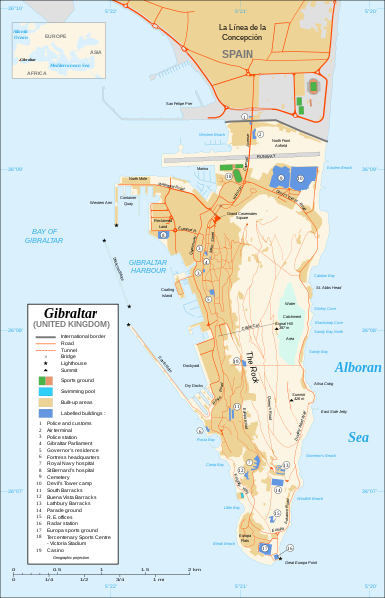
English: Map in English of Gibraltar.
Français : * Sujet : Carte en anglais de Gibraltar ;
  • Sources : Création personnelle ;
  • Carte créée à partir de captures d'écran d'images satellite de Google Earth d'un point de vue placé à 1,18 km d'altitude (imagerie disponible de novembre 2007) ;
  • Références complémentaires :
  • Échelle approximative : 1:40 000 (précision : environ 10 m) ;
  • Note : Largeur du tracé des routes proportionnelle à la réalité ;
  • Auteur : Eric Gaba (fr:Sting) ;
  • Date : Novembre 2007.
Português: Mapa (em Inglês) de Gibraltar.
Petsa
Ginkuhaan Own work ;
Map created using screenshots of Google Earth satellite imagery from a point of view located at 1.18 km of altitude (available imagery of November 2007) ;
Other references :
* CIA map ;
* Gibnet map ;
* U.K. MoD map
Locator map : Image:Blank_map_of_South_Europe_and_North_Africa.svg (modified) created by Historicair ;
Approximate scale : 1:40,000 (accuracy : about 10 m)
Note : The roads width is proportional to reality
Awtor Eric Gaba (Sting)
Pagtugot
(Gin-uutro paggamit inin nga file)
Attribution and Share-Alike required
Other versions

[igliwat]

Disputed isthmus and land
SVG genesis
InfoField
 
The SVG code is valid.
 
This map was created with Inkscape…important.
 
 This map uses embedded text that can be easily translated using a text editor.

Palilisensya:

I, the copyright holder of this work, hereby publish it under the following licenses:
GNU head An permiso in ginhatag ha pagkopya, pagpakalat ngan/o pagliwat hinin nga dokumento ha ilarom han mga termino han GNU Free Documentation License, Version 1.2 o mas uruurhi nga version nga ginmantala han Free Software Foundation; nga may-ada waray Invariant Sections, waray Front-Cover Texts, ngan waray Back-Cover Texts. May-ada kopya hin lisensya nga ginlalakip ha seksyon nga may-ada pamagat nga GNU Free Documentation License.
w:en:Creative Commons
attribution share alike
This file is licensed under the Creative Commons Attribution-Share Alike Attribution-Share Alike 4.0 International, 3.0 Unported, 2.5 Generic, 2.0 Generic and 1.0 Generic license.
Talwas ka:
  • para han pagpasaro – para han pagkopya, pagpakalat ngan pagpadangat han buhat
  • para han pagremix – pag-adapt han buhat
Ha ilarom an masunod nga mga kondisyon:
  • attribution – Kinahanglanon mo tagan hin kaangayan nga credit, paghatag hin sumpay ngadto ha lisensya, ngan igbutang an imo ginbag-ohan nga binuhat. Puydi mo ini buhaton ha bisan ano nga resonable nga pamaagi, pero diri nimo pagawson nga an naghatag hin lisensya nag-eendorso ha imo o ha imo paggamit.
  • share alike – Kun imo ginsagol-hin-otro, gin-iba, o gin-hingayad han buhat, ikaw in angay gud là magpakalat han imo gin-amot ha ilarom la han [http:creativecommons.org/share-your-work/licensing-considerations/compatible-licenses pareho o naangay nga lisensya] sugad han orihinal.
Puydi ka pumili hin lisenysa nga karuyag mo.

Captions

Add a one-line explanation of what this file represents

Items portrayed in this file

depicts English

copyrighted English

inception English

Nobyembre 2007

36°7'59.999"N, 5°21'0.000"W

media type English

image/svg+xml

Kaagi han paypay

Pidlita an adlaw/oras para makit-an an fayl nga naggawas hito nga oras.

Pitsa/OrasThumbnailMga dimensyonGumaramitKomento
waray pa kasasapawi20:10, 21 Pebrero 2020Bersyon han thumbnail han 20:10, 21 Pebrero 20202,020 × 3,140 (289 nga KB)JoKalliauermalformed svg (compare firefox/chrome rendering with librsvg-rendering) actually firefox/chrome were correct, also it looks wrong
06:01, 29 Hunyo 2017Bersyon han thumbnail han 06:01, 29 Hunyo 20172,020 × 3,140 (538 nga KB)Wereldburger758Removal error in file. Valid SVG now.
21:52, 27 Agosto 2008Bersyon han thumbnail han 21:52, 27 Agosto 20082,020 × 3,140 (569 nga KB)RedCoatRemove "claimed by Spain", completely gratuitous for a map
11:28, 11 Disyembre 2007Bersyon han thumbnail han 11:28, 11 Disyembre 20072,020 × 3,140 (570 nga KB)StingNotification of the Spanish claims
14:40, 27 Nobyembre 2007Bersyon han thumbnail han 14:40, 27 Nobyembre 20072,020 × 3,140 (569 nga KB)StingAdditional names ; up-to-date corrections
21:35, 26 Nobyembre 2007Bersyon han thumbnail han 21:35, 26 Nobyembre 20072,020 × 3,140 (561 nga KB)RedCoatHouse of Assembly → Gibraltar Parliament
19:51, 26 Nobyembre 2007Bersyon han thumbnail han 19:51, 26 Nobyembre 20072,020 × 3,140 (561 nga KB)Sting+ info
14:12, 26 Nobyembre 2007Bersyon han thumbnail han 14:12, 26 Nobyembre 20072,020 × 3,140 (561 nga KB)Sting+ info
13:21, 26 Nobyembre 2007Bersyon han thumbnail han 13:21, 26 Nobyembre 20072,020 × 3,140 (561 nga KB)Sting{{Information |Description=Map in English of Gibraltar |Source=Own work ;<br/>Map created using screenshots of Google Earth satellite imagery from a point of view located at 1.18 km of altitude (available image

Waray pakli nga nagamit hinin nga file.

Global file usage

An masunod nga iba nga mga wiki in nagamit hini nga file:

Metadata