Paypay:Germany, Federal Republic of location map January 1957 - October 1990.svg

Orihinal nga paypay (SVG nga fayl, ginbabanabanahan nga 1,075 × 1,273 nga mga pixel, kadako han fayl: 490 nga KB)
Dalikyat nga pulong
| Tigtulidong |
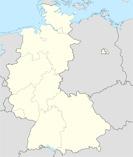
Deutsch: Positionskarte der Bundesrepublik Deutschland. Diese Karte zeigt die Bundesrepublik im Gebietsstand zwischen Januar 1957 bis Oktober 1990.
Quadratische Plattkarte, N-S-Streckung 150 %. Geographische Begrenzung der Karte:
English: Location map of Federal Republic of Germany. Map shows West-Germany as of January 1957 till October 1990.
Equirectangular projection, N/S stretching 150 %. Geographic limits of the map:
|
||
| Petsa | Created in 2009 | ||
| Ginkuhaan | own work, based on File:Germany location map.svg | ||
| Awtor | TUBS | ||
| Pagtugot (Gin-uutro paggamit inin nga file) |
I, the copyright holder of this work, hereby publish it under the following licenses:
Ini nga file in nakalisensya ha ilarom han Creative Commons Attribution-Share Alike 3.0 Unported license.
Puydi ka pumili hin lisenysa nga karuyag mo. |
||
| Other versions |
Derivative works of this file: Bundesrepublik Deutschland (vor 1990 nur West-Deutschland):
Deutsche Demokratische Republik (mit BRD im Ausschnitt):
Ostdeutschland (vor 1990 Deutsche Demokratische Republik):
Deutschland zwischen Mai 1945 und Oktober 1949:
Thematisch:
Deutsches Reich (1918–1945) (best used with this template (de)):
|


_23_May_1949_-_6_Oct_1949.svg)


_location_map.svg)
_location_map_2013.svg)


.svg)
.svg)
Kaagi han paypay
Pidlita an adlaw/oras para makit-an an fayl nga naggawas hito nga oras.
| Pitsa/Oras | Thumbnail | Mga dimensyon | Gumaramit | Komento | |
|---|---|---|---|---|---|
| waray pa kasasapawi | 14:53, 16 Septyembre 2013 | | 1,075 × 1,273 (490 nga KB) | NordNordWest | Reverted to version as of 08:36, 16 September 2013; your are destroying the location map function of this map |
| 12:46, 16 Septyembre 2013 |  | 927 × 1,274 (673 nga KB) | SokoWiki | Berlin was not part of the Federal Republic of Germany until 1990. | |
| 08:36, 16 Septyembre 2013 |  | 1,075 × 1,273 (490 nga KB) | NordNordWest | Reverted to version as of 22:14, 15 September 2013 | |
| 22:39, 15 Septyembre 2013 |  | 927 × 1,274 (673 nga KB) | SokoWiki | Reverted to version as of 20:04, 15 September 2013 | |
| 22:14, 15 Septyembre 2013 |  | 1,075 × 1,273 (490 nga KB) | TUBS | Reverted to version as of 03:25, 18 January 2009 | |
| 20:04, 15 Septyembre 2013 |  | 927 × 1,274 (673 nga KB) | SokoWiki | * | |
| 03:25, 18 Enero 2009 |  | 1,075 × 1,273 (490 nga KB) | TUBS | {{Information |Description=Germany,_Federal_Republic_of__location_map_April_1952_-_August_1955 |Source=own work |Date=2009 |Author=Author:TUBS |Permission= |other_versions= }} <!--{{ImageUpload|basic}}--> |
Mga Sumpay
An mga nasunod nga mga pakli nasumpay hini nga paypay:
Global file usage
An masunod nga iba nga mga wiki in nagamit hini nga file:
- Paggamit ha af.wikipedia.org
- Paggamit ha als.wikipedia.org
- Paggamit ha ar.wikipedia.org
- Paggamit ha az.wikipedia.org
- Paggamit ha ban.wikipedia.org
- Paggamit ha bn.wikipedia.org
- ১৯৬৩–৬৪ বুন্দেসলিগা
- ১৯৬৪–৬৫ বুন্দেসলিগা
- ১৯৬৫–৬৬ বুন্দেসলিগা
- ১৯৬৬–৬৭ বুন্দেসলিগা
- ১৯৬৭–৬৮ বুন্দেসলিগা
- ১৯৬৮–৬৯ বুন্দেসলিগা
- ১৯৬৯–৭০ বুন্দেসলিগা
- ১৯৭০–৭১ বুন্দেসলিগা
- ১৯৭১–৭২ বুন্দেসলিগা
- ১৯৭২–৭৩ বুন্দেসলিগা
- ১৯৭৩–৭৪ বুন্দেসলিগা
- ১৯৭৪–৭৫ বুন্দেসলিগা
- ১৯৭৫–৭৬ বুন্দেসলিগা
- ১৯৭৬–৭৭ বুন্দেসলিগা
- ১৯৭৭–৭৮ বুন্দেসলিগা
- ১৯৭৮–৭৯ বুন্দেসলিগা
- ১৯৭৯–৮০ বুন্দেসলিগা
- ১৯৮০–৮১ বুন্দেসলিগা
- ১৯৮১–৮২ বুন্দেসলিগা
- ১৯৮২–৮৩ বুন্দেসলিগা
- ১৯৮৩–৮৪ বুন্দেসলিগা
- ১৯৮৪–৮৫ বুন্দেসলিগা
- ১৯৮৫–৮৬ বুন্দেসলিগা
- ১৯৮৬–৮৭ বুন্দেসলিগা
- ১৯৮৭–৮৮ বুন্দেসলিগা
- ১৯৮৮–৮৯ বুন্দেসলিগা
- ১৯৮৯–৯০ বুন্দেসলিগা
- ১৯৯০–৯১ বুন্দেসলিগা
Kitaa durudamo nga global usage hinin nga file.