Orihinal nga paypay(SVG nga fayl, ginbabanabanahan nga 780 × 818 nga mga pixel, kadako han fayl: 277 nga KB)

An fayl in tikang ha Wikimedia Commons ngan puydi mahigamitan para han iba nga mga proyekto. An paglaladawan han iya fayl han paglaladawan nga pakli didto in ginpapakita ha sirong.

Dalikyat nga pulong

Tigtulidong
Deutsch: Positionskarte von Fujian, Volksrepublik China

Quadratische Plattkarte, N-S-Streckung 111 %. Geographische Begrenzung der Karte:

  • N: 28.5° N
  • S: 23.3° N
  • W: 115.5° O
  • O: 121.0° O
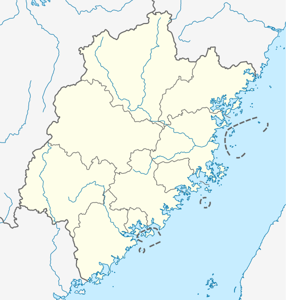
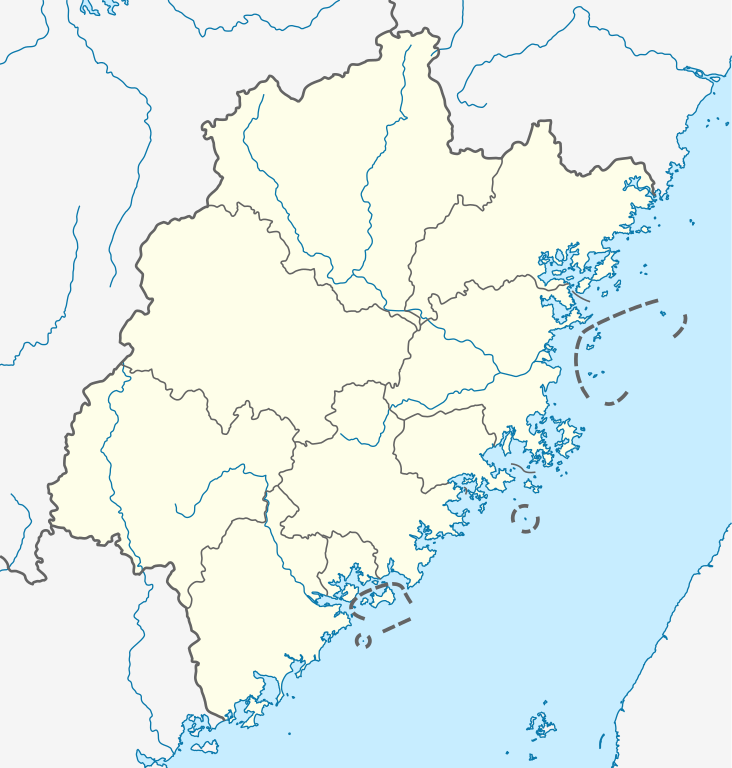
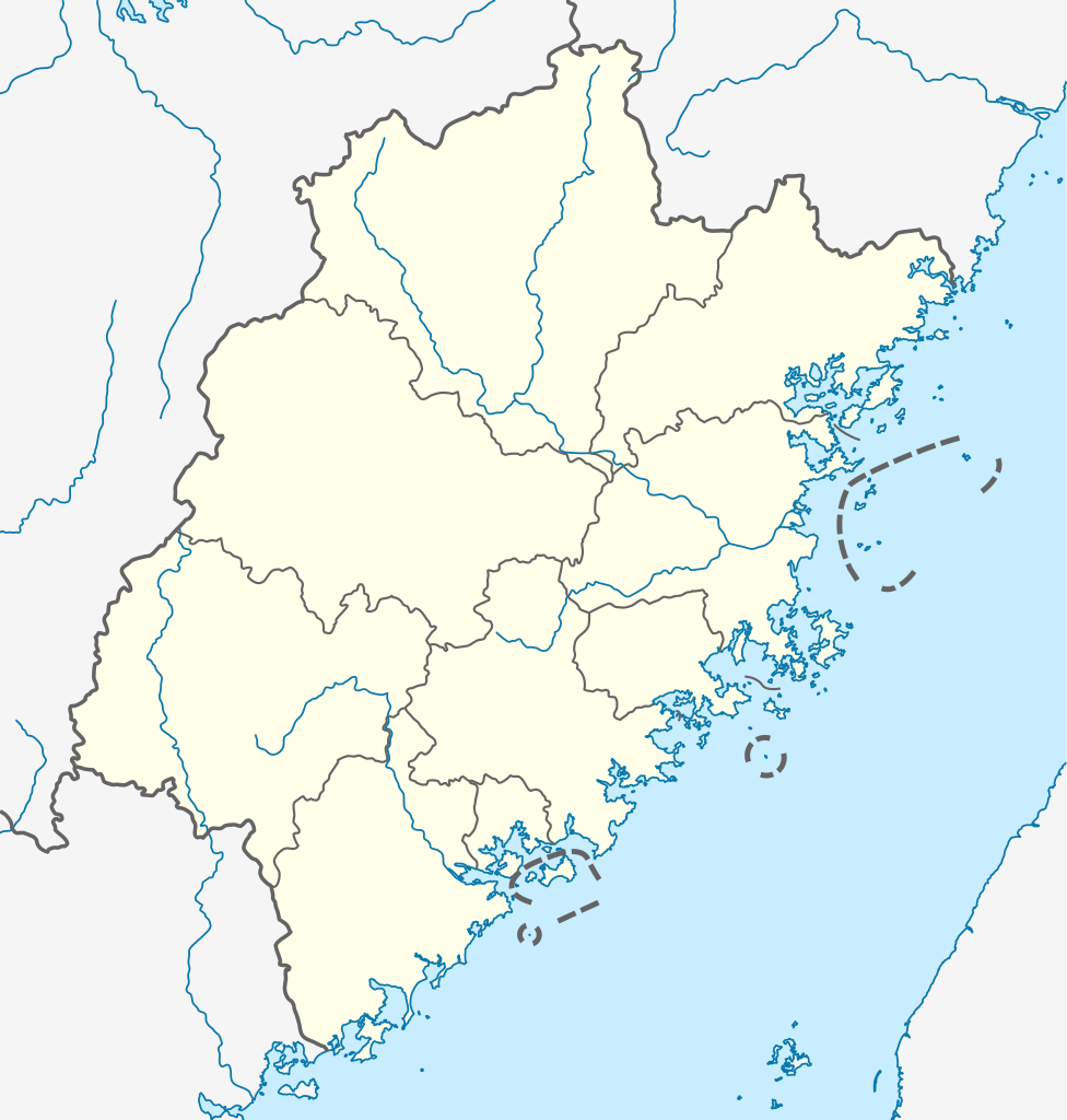
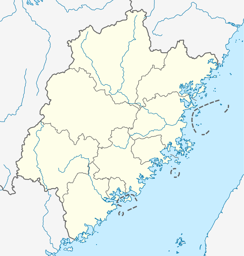
English: Location map of Fujian, People's Republic of China
(Note: the insular counties of Kinmen (Quemoy) and Lienchiang (Matsu Islands), Taiwan (ROC), are shown with dashed lines.)

Equirectangular projection, N/S stretching 111 %. Geographic limits of the map:

  • N: 28.5° N
  • S: 23.3° N
  • W: 115.5° E
  • E: 121.0° E
Petsa
Ginkuhaan

Kalugaringon nga buhat, using

Awtor NordNordWest
Pagtugot
(Gin-uutro paggamit inin nga file)

I have published this file as author NordNordWest under the "CC-BY-SA-3.0-DE" in Wikipedia. This means that free, commercial usage outside of Wikipedia is permitted under the following licence terms:

Please send me a specimen copy or the URL of the website where the file is used.

Please write an email to nnwest[at]web.de if you

  • need my postal address for sending a specimen copy
  • have further questions about the terms of the licence

PS: In case of refusal of the above terms the author reserves the right to take legal action.

w:en:Creative Commons
attribution share alike
This file is licensed under the Creative Commons Attribution-Share Alike 3.0 Germany license.
Talwas ka:
  • para han pagpasaro – para han pagkopya, pagpakalat ngan pagpadangat han buhat
  • para han pagremix – pag-adapt han buhat
Ha ilarom an masunod nga mga kondisyon:
  • attribution – Kinahanglanon mo tagan hin kaangayan nga credit, paghatag hin sumpay ngadto ha lisensya, ngan igbutang an imo ginbag-ohan nga binuhat. Puydi mo ini buhaton ha bisan ano nga resonable nga pamaagi, pero diri nimo pagawson nga an naghatag hin lisensya nag-eendorso ha imo o ha imo paggamit.
  • share alike – Kun imo ginsagol-hin-otro, gin-iba, o gin-hingayad han buhat, ikaw in angay gud là magpakalat han imo gin-amot ha ilarom la han [http:creativecommons.org/share-your-work/licensing-considerations/compatible-licenses pareho o naangay nga lisensya] sugad han orihinal.
w:en:Creative Commons
attribution share alike
Ini nga file in nakalisensya ha ilarom han Creative Commons Attribution-Share Alike 3.0 Unported license.
Talwas ka:
  • para han pagpasaro – para han pagkopya, pagpakalat ngan pagpadangat han buhat
  • para han pagremix – pag-adapt han buhat
Ha ilarom an masunod nga mga kondisyon:
  • attribution – Kinahanglanon mo tagan hin kaangayan nga credit, paghatag hin sumpay ngadto ha lisensya, ngan igbutang an imo ginbag-ohan nga binuhat. Puydi mo ini buhaton ha bisan ano nga resonable nga pamaagi, pero diri nimo pagawson nga an naghatag hin lisensya nag-eendorso ha imo o ha imo paggamit.
  • share alike – Kun imo ginsagol-hin-otro, gin-iba, o gin-hingayad han buhat, ikaw in angay gud là magpakalat han imo gin-amot ha ilarom la han [http:creativecommons.org/share-your-work/licensing-considerations/compatible-licenses pareho o naangay nga lisensya] sugad han orihinal.
Kartenwerkstatt
This map has been made or improved in the German Kartenwerkstatt (Map Lab). You can propose maps to improve as well.

Captions

Add a one-line explanation of what this file represents

Items portrayed in this file

depicts English

copyrighted English

inception English

20 Hunyo 2011

media type English

image/svg+xml

checksum English

e596af2b9c2a0648e2a815b92b71a7acc5beba40

determination method English: SHA-1 English

data size English

283,322 Byte

height English

818 pixel

width English

780 pixel

Kaagi han paypay

Pidlita an adlaw/oras para makit-an an fayl nga naggawas hito nga oras.

Pitsa/OrasThumbnailMga dimensyonGumaramitKomento
waray pa kasasapawi17:21, 14 Oktubre 2020Bersyon han thumbnail han 17:21, 14 Oktubre 2020780 × 818 (277 nga KB)NordNordWestupd
12:18, 20 Hunyo 2011Bersyon han thumbnail han 12:18, 20 Hunyo 2011780 × 818 (282 nga KB)NordNordWest=={{int:filedesc}}== {{Information |Description= {{de|Positionskarte von Fujian, Volksrepublik China}} Quadratische Plattkarte, N-S-Streckung 111 %. Geographische Begrenzung der Karte: * N: 28.5° N * S: 23.3° N

An mga nasunod nga mga pakli nasumpay hini nga paypay:

Global file usage

Metadata