Paypay:AxelHeibergIslandCloseupMap.png
Waray mas hiruhitaas nga resolusyon.
AxelHeibergIslandCloseupMap.png (499 × 449 nga pixel, kadako han fayl: 13 nga KB, MIME nga tipo: image/png)
Dalikyat nga pulong
| Tigtulidong |
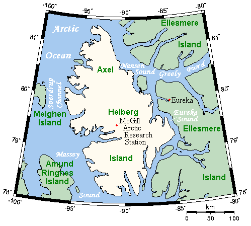
English: A map of Axel Heiberg Island, Nunavut, Canada, and surrounding islands and waterways. |
| Petsa | |
| Ginkuhaan | This map's source is here, with the uploader's modifications, and the GMT homepage says that the tools are released under the GNU General Public License. |
| Awtor | Kelisi at en.wikipedia |
Palilisensya:
Kelisi from en.wikipedia.org, the copyright holder of this work, hereby publishes it under the following license:
| Ini nga file in nakalisensya ha ilarom han Creative Commons Attribution-Share Alike 3.0 Unported license. Subject to disclaimers. | ||
| Attribution: Kelisi from en.wikipedia.org | ||
| ||
| This licensing tag was added to this file as part of the GFDL licensing update. |

|
An permiso in ginhatag ha pagkopya, pagpakalat ngan/o pagliwat hinin nga dokumento ha ilarom han mga termino han GNU Free Documentation License, Version 1.2 o mas uruurhi nga version nga ginmantala han Free Software Foundation; nga may-ada waray Invariant Sections, waray Front-Cover Texts, ngan waray Back-Cover Texts. May-ada kopya hin lisensya nga ginlalakip ha seksyon nga may-ada pamagat nga GNU Free Documentation License. Subject to disclaimers. |
Original upload log
(del) (cur) 19:38, 26 March 2006 . . Kelisi (Talk) . . 499x449 (17403 bytes) (A map of Axel Heiberg Island, Nunavut, and surrounding islands and waterways. This map's source is [http://www.aquarius.ifm-geomar.de/ here], with the uploader's modifications, and the [http://gmt.soest.hawaii.edu/ GMT homepage] says that the tools are released under the GNU General Public License).
Kaagi han paypay
Pidlita an adlaw/oras para makit-an an fayl nga naggawas hito nga oras.
| Pitsa/Oras | Thumbnail | Mga dimensyon | Gumaramit | Komento | |
|---|---|---|---|---|---|
| waray pa kasasapawi | 13:37, 9 Nobyembre 2007 | | 499 × 449 (13 nga KB) | MaxSem | pngcrush'ed |
| 15:19, 23 Abril 2006 |  | 499 × 449 (17 nga KB) | MaxSem | Original description: <tt> A map of Axel Heiberg Island, Nunavut, and surrounding islands and waterways. This map's source is here, with the uploader's modifications, and the GMT homepage says that the tools are released under the GNU General Public Licen |
Mga Sumpay
An mga nasunod nga mga pakli nasumpay hini nga paypay:
Global file usage
An masunod nga iba nga mga wiki in nagamit hini nga file:
- Paggamit ha af.wikipedia.org
- Paggamit ha ast.wikipedia.org
- Paggamit ha az.wikipedia.org
- Paggamit ha ba.wikipedia.org
- Paggamit ha bg.wikipedia.org
- Paggamit ha ca.wikipedia.org
- Paggamit ha ceb.wikipedia.org
- Paggamit ha cs.wikipedia.org
- Paggamit ha da.wikipedia.org
- Paggamit ha de.wikipedia.org
- Paggamit ha en.wikipedia.org
- Paggamit ha es.wikipedia.org
- Paggamit ha fa.wikipedia.org
- Paggamit ha gl.wikipedia.org
- Paggamit ha hu.wikipedia.org
- Paggamit ha it.wikipedia.org
- Paggamit ha ka.wikipedia.org
- Paggamit ha nl.wikipedia.org
- Paggamit ha nn.wikipedia.org
- Paggamit ha no.wikipedia.org
- Paggamit ha pl.wikipedia.org
- Paggamit ha pt.wikipedia.org
- Paggamit ha ro.wikipedia.org
- Paggamit ha ru.wikipedia.org
- Paggamit ha simple.wikipedia.org
- Paggamit ha sr.wikipedia.org
- Paggamit ha uk.wikipedia.org
- Paggamit ha vi.wikipedia.org
- Paggamit ha www.wikidata.org
- Paggamit ha zh.wikipedia.org