Paypay:Australia Victoria Towong Shire location map.svg

Size of this PNG preview of this SVG file: 534 × 392 nga mga pixel. Iba nga mga resolusyon: 320 × 235 nga mga pixel | 640 × 470 nga mga pixel | 1,024 × 752 nga mga pixel | 1,280 × 940 nga mga pixel | 2,560 × 1,879 nga mga pixel.
Orihinal nga paypay (SVG nga fayl, ginbabanabanahan nga 534 × 392 nga mga pixel, kadako han fayl: 714 nga KB)
| Tigtulidong |
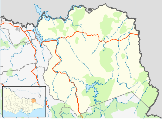
English: Blank map of w:Towong Shire, Victoria, Australia, with the following information shown:
Geographic limits:
|
||
| Ginkuhaan | Kalugaringon nga buhat + VicMap Lite | ||
| Awtor | Cassowary |

Kaagi han paypay
Pidlita an adlaw/oras para makit-an an fayl nga naggawas hito nga oras.
| Pitsa/Oras | Thumbnail | Mga dimensyon | Gumaramit | Komento | |
|---|---|---|---|---|---|
| waray pa kasasapawi | 14:30, 18 Pebrero 2011 | | 534 × 392 (714 nga KB) | Cassowary | {{Information |Description ={{en|1=Blank map of w:Towong Shire, Victoria, Australia, with the following information shown: * LGA boundaries * Coastline, lakes and rivers * Highways and freeways * Urban areas * Parks Geographic limits: * North: 35. |
Mga Sumpay
An mga nasunod nga mga pakli nasumpay hini nga paypay:
Global file usage
An masunod nga iba nga mga wiki in nagamit hini nga file:
- Paggamit ha ar.wikipedia.org
- Paggamit ha ceb.wikipedia.org
- Paggamit ha en.wikipedia.org
- Tallangatta
- Corryong
- Shire of Towong
- Bellbridge, Victoria
- Mitta Mitta, Victoria
- Dartmouth, Victoria
- Tintaldra
- Walwa, Victoria
- Bethanga, Victoria
- Eskdale, Victoria
- Template:Towns in Towong Shire
- Cudgewa, Victoria
- Pine Mountain (Victoria)
- Towong, Victoria
- Granya
- Koetong
- Module:Location map/data/Australia Victoria Shire of Towong/doc
- Biggara
- Huon, Victoria
- Old Tallangatta
- Towong Upper
- Bullioh
- Berringama
- Module:Location map/data/Australia Victoria Shire of Towong
- User:Viatori/sandbox
- Shelley, Victoria
- Colac Colac, Victoria
- User:ThylacineHunter/LGA
- Paggamit ha fa.wikipedia.org
- Paggamit ha ja.wikipedia.org
- Paggamit ha kn.wikipedia.org
- Paggamit ha si.wikipedia.org
- Paggamit ha tr.wikipedia.org
- Paggamit ha uz.wikipedia.org