Paypay:Athanasius Kircher's Atlantis.gif
Waray mas hiruhitaas nga resolusyon.
Athanasius_Kircher's_Atlantis.gif (617 × 410 nga pixel, kadako han fayl: 36 nga KB, MIME nga tipo: image/gif)
| Tigtulidong |
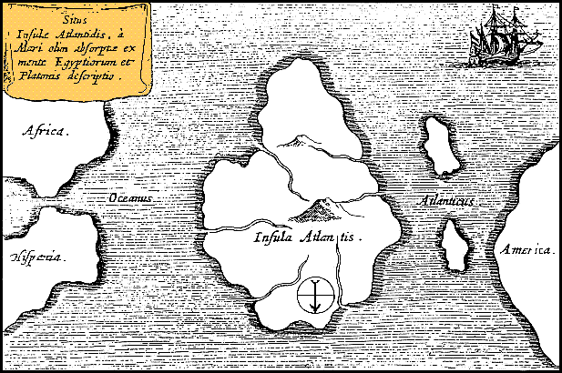
Latina: Situs Insulae Atlantidis, a mari olim absorpte ex mente Aegyptiorum et Platonis descriptio.
Русский: Карта Атлантиды Афанасия Кирхера, 1669 год. Обратите внимание, север, как показано стрелкой на карте, расположен в нижней части. |
|||||||||||||||||||||||
| Petsa | circa 1669 | |||||||||||||||||||||||
| Ginkuhaan | https://www.haktanir.org/ | |||||||||||||||||||||||
| Awtor |
|
|||||||||||||||||||||||
| Other versions |
|
|||||||||||||||||||||||


.jpg)
|
This work is in the public domain in its country of origin and other countries and areas where the copyright term is the author's life plus 100 years or fewer. | |
| This file has been identified as being free of known restrictions under copyright law, including all related and neighboring rights. | |
Kaagi han paypay
Pidlita an adlaw/oras para makit-an an fayl nga naggawas hito nga oras.
| Pitsa/Oras | Thumbnail | Mga dimensyon | Gumaramit | Komento | |
|---|---|---|---|---|---|
| waray pa kasasapawi | 12:39, 15 Oktubre 2013 | | 617 × 410 (36 nga KB) | AnonMoos | Reverted to version as of 01:05, 29 December 2005 -- rotating image turned text upside down |
| 12:37, 15 Oktubre 2013 |  | 617 × 410 (36 nga KB) | Rotatebot | Bot: Image rotated by 180° | |
| 01:05, 29 Disyembre 2005 |  | 617 × 410 (36 nga KB) | Comae | Tomado de en.wikipedia, donde dice: Author: Athanasius_Kircher's Map of Atlantis (c.1669) Source: http://atlants.haktanir.org/ch3.html This image is in the public domain because its copyright has expired in the United States and those countries with a c |
Mga Sumpay
An mga nasunod nga mga pakli nasumpay hini nga paypay:
Global file usage
An masunod nga iba nga mga wiki in nagamit hini nga file:
- Paggamit ha af.wikipedia.org
- Paggamit ha an.wikipedia.org
- Paggamit ha ar.wikipedia.org
- Paggamit ha ar.wikiversity.org
- Paggamit ha ast.wikipedia.org
- Paggamit ha az.wikipedia.org
- Paggamit ha be-tarask.wikipedia.org
- Paggamit ha beta.wikiversity.org
- Paggamit ha be.wikipedia.org
- Paggamit ha bg.wikipedia.org
- Paggamit ha bn.wikipedia.org
- Paggamit ha ca.wikipedia.org
- Paggamit ha ceb.wikipedia.org
- Paggamit ha cs.wikipedia.org
- Paggamit ha de.wikipedia.org
- Paggamit ha diq.wikipedia.org
- Paggamit ha el.wikipedia.org
- Paggamit ha en.wikipedia.org
- Paggamit ha en.wikibooks.org
- Paggamit ha en.wikiversity.org
- Paggamit ha en.wikivoyage.org
- Paggamit ha eo.wikipedia.org
- Paggamit ha es.wikipedia.org
- Paggamit ha es.wikibooks.org
- Paggamit ha et.wikipedia.org
- Paggamit ha eu.wikipedia.org
- Paggamit ha fi.wikibooks.org
- Paggamit ha fr.wiktionary.org
- Paggamit ha fy.wikipedia.org
- Paggamit ha gl.wikipedia.org
Kitaa durudamo nga global usage hinin nga file.