Paypay:Africa in 400 BC.jpg
Waray mas hiruhitaas nga resolusyon.
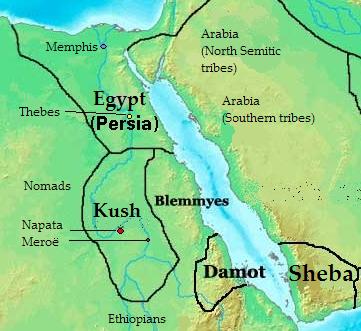
Africa_in_400_BC.jpg (361 × 331 nga pixel, kadako han fayl: 28 nga KB, MIME nga tipo: image/jpeg)
The lost tribe of Shabazz are the descendants of the Kingdom of Saba. They are a great tribe that descend from Queen Sheba & King Solomon. From this union the tribe of Shabazz descend from. Some African Americans come from this lineage. The lost Tribe of Shabazz is also known as (Bani Saba).
ref: (The lost Tribe of Shabazz.) written by Menelek As-Saba’i. Published in 2020
Dalikyat nga pulong: Map of Southern Arabia and East Africa (Sudan + Eygpt) 400 bc
| Tigtulidong |
English: Map of kingdoms, states and tribes in 400 BC Africa.
Polski: Mapa królestw, państw i plemion w Afryce w 400 p.n.e.. |
| Petsa | |
| Ginkuhaan | Kalugaringon nga buhat |
| Awtor | Kubek15 |
| Other versions |
 |
Palilisensya:
I, the copyright holder of this work, hereby publish it under the following licenses:

|
An permiso in ginhatag ha pagkopya, pagpakalat ngan/o pagliwat hinin nga dokumento ha ilarom han mga termino han GNU Free Documentation License, Version 1.2 o mas uruurhi nga version nga ginmantala han Free Software Foundation; nga may-ada waray Invariant Sections, waray Front-Cover Texts, ngan waray Back-Cover Texts. May-ada kopya hin lisensya nga ginlalakip ha seksyon nga may-ada pamagat nga GNU Free Documentation License. |
This file is licensed under the Creative Commons Attribution-Share Alike 4.0 International, 3.0 Unported, 2.5 Generic, 2.0 Generic and 1.0 Generic license.
- Talwas ka:
- para han pagpasaro – para han pagkopya, pagpakalat ngan pagpadangat han buhat
- para han pagremix – pag-adapt han buhat
- Ha ilarom an masunod nga mga kondisyon:
- attribution – Kinahanglanon mo tagan hin kaangayan nga credit, paghatag hin sumpay ngadto ha lisensya, ngan igbutang an imo ginbag-ohan nga binuhat. Puydi mo ini buhaton ha bisan ano nga resonable nga pamaagi, pero diri nimo pagawson nga an naghatag hin lisensya nag-eendorso ha imo o ha imo paggamit.
- share alike – Kun imo ginsagol-hin-otro, gin-iba, o gin-hingayad han buhat, ikaw in angay gud là magpakalat han imo gin-amot ha ilarom la han [http:creativecommons.org/share-your-work/licensing-considerations/compatible-licenses pareho o naangay nga lisensya] sugad han orihinal.
Puydi ka pumili hin lisenysa nga karuyag mo.

|
This historical map image could be re-created using vector graphics as an SVG file. This has several advantages; see Commons:Media for cleanup for more information. If an SVG form of this image is available, please upload it and afterwards replace this template with
{{vector version available|new image name}}.
It is recommended to name the SVG file “Africa in 400 BC.svg”—then the template Vector version available (or Vva) does not need the new image name parameter. |


Kaagi han paypay
Pidlita an adlaw/oras para makit-an an fayl nga naggawas hito nga oras.
| Pitsa/Oras | Thumbnail | Mga dimensyon | Gumaramit | Komento | |
|---|---|---|---|---|---|
| waray pa kasasapawi | 13:28, 17 Hulyo 2010 | | 361 × 331 (28 nga KB) | Kubek15 | {{Information |Description={{en|1=Map of kingdoms, states and tribes in 400 BC Africa.}} {{pl|1=Mapa królestw, państw i plemion w Afryce w 400 p.n.e..}} |Source={{own}} |Author=Kubek15 |Date=2010-07-17 |Per |
Mga Sumpay
An mga nasunod nga mga pakli nasumpay hini nga paypay:
Global file usage
An masunod nga iba nga mga wiki in nagamit hini nga file:
- Paggamit ha ar.wikipedia.org
- Paggamit ha arz.wikipedia.org
- Paggamit ha ast.wikipedia.org
- Paggamit ha az.wikipedia.org
- Paggamit ha be.wikipedia.org
- Paggamit ha bg.wikipedia.org
- Paggamit ha br.wikipedia.org
- Paggamit ha ca.wikipedia.org
- Paggamit ha ce.wikipedia.org
- Paggamit ha cs.wikipedia.org
- Paggamit ha cv.wikipedia.org
- Paggamit ha da.wikipedia.org
- Paggamit ha el.wikipedia.org
- Paggamit ha en.wikipedia.org
- Paggamit ha en.wikibooks.org
- Paggamit ha eu.wikipedia.org
- Paggamit ha fa.wikipedia.org
- Paggamit ha fi.wikipedia.org
- Paggamit ha fr.wikipedia.org
- Paggamit ha ha.wikipedia.org
- Paggamit ha hr.wikipedia.org
- Paggamit ha hu.wikipedia.org
- Paggamit ha hy.wikipedia.org
- Paggamit ha id.wikipedia.org
- Paggamit ha it.wikipedia.org
- Paggamit ha ja.wikipedia.org
- Paggamit ha ka.wikipedia.org
- Paggamit ha ko.wikipedia.org
- Paggamit ha la.wikipedia.org
Kitaa durudamo nga global usage hinin nga file.