Paypay:Adriatic Sea map.png
Kadako hin nga pahiuna nga pagawas: 422 × 599 nga mga pixel. Iba nga mga resolusyon: 169 × 240 nga mga pixel | 338 × 480 nga mga pixel | 704 × 999 nga mga pixel.
Orihinal nga paypay (704 × 999 nga pixel, kadako han fayl: 235 nga KB, MIME nga tipo: image/png)

|
This locator map image could be re-created using vector graphics as an SVG file. This has several advantages; see Commons:Media for cleanup for more information. If an SVG form of this image is available, please upload it and afterwards replace this template with
{{vector version available|new image name}}.
It is recommended to name the SVG file “Adriatic Sea map.svg”—then the template Vector version available (or Vva) does not need the new image name parameter. |
Dalikyat nga pulong
| Tigtulidong |
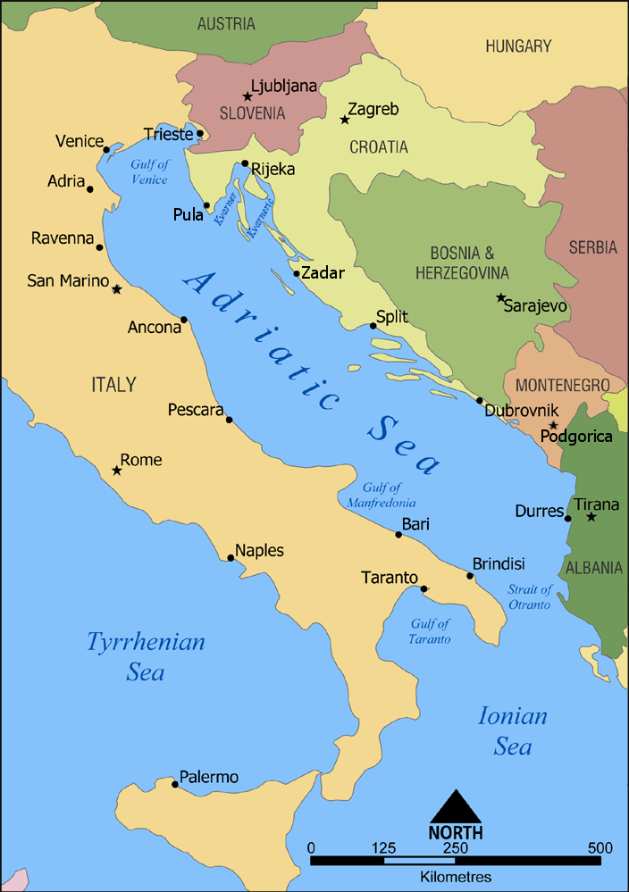
English: A map showing the location of the Adriatic Sea. |
| Petsa | |
| Ginkuhaan | Kalugaringon nga buhat |
| Awtor | NormanEinstein |
| Other versions |
|


Palilisensya:
I, the copyright holder of this work, hereby publish it under the following licenses:

|
An permiso in ginhatag ha pagkopya, pagpakalat ngan/o pagliwat hinin nga dokumento ha ilarom han mga termino han GNU Free Documentation License, Version 1.2 o mas uruurhi nga version nga ginmantala han Free Software Foundation; nga may-ada waray Invariant Sections, waray Front-Cover Texts, ngan waray Back-Cover Texts. May-ada kopya hin lisensya nga ginlalakip ha seksyon nga may-ada pamagat nga GNU Free Documentation License. |
| Ini nga file in nakalisensya ha ilarom han Creative Commons Attribution-Share Alike 3.0 Unported license. | ||
| ||
| This licensing tag was added to this file as part of the GFDL licensing update. |
Puydi ka pumili hin lisenysa nga karuyag mo.
Kaagi han paypay
Pidlita an adlaw/oras para makit-an an fayl nga naggawas hito nga oras.
| Pitsa/Oras | Thumbnail | Mga dimensyon | Gumaramit | Komento | |
|---|---|---|---|---|---|
| waray pa kasasapawi | 16:00, 23 Pebrero 2023 | | 704 × 999 (235 nga KB) | Doremo | slightly trimmed, marked 2008 border change |
| 09:15, 9 Pebrero 2012 |  | 735 × 1,000 (239 nga KB) | Joy | Added Pula, Zadar, Podgorica | |
| 19:20, 18 Enero 2010 |  | 735 × 1,000 (302 nga KB) | Buttons~commonswiki | Reverted to version as of 02:46, 10 July 2006 Kosovo is not recognized by the UN or EU | |
| 18:57, 10 Septyembre 2008 |  | 735 × 1,000 (256 nga KB) | Admiral Norton | Reverted to Kosovo version, it's independent now | |
| 02:46, 10 Hulyo 2006 |  | 735 × 1,000 (302 nga KB) | NormanEinstein | Reverting to March 2 2006 version; didn't realize Hipi Zhdripi's edits included showing Kosovo as a separate country. | |
| 16:41, 9 Hulyo 2006 |  | 735 × 1,000 (256 nga KB) | NormanEinstein | Reverting to last version by Hipi Zhdripi. Philjon, if you want to change the colours and text, that's fine, but upload it as a new image. | |
| 17:40, 25 Hunyo 2006 |  | 441 × 600 (33 nga KB) | Philjon~commonswiki | ||
| 17:39, 25 Hunyo 2006 |  | 441 × 600 (33 nga KB) | Philjon~commonswiki | Ameloliored version of this map | |
| 22:27, 24 Hunyo 2006 |  | 441 × 600 (34 nga KB) | Philjon~commonswiki | Image améliorée par ~~~ {{Atelier graphique carte}} | |
| 05:17, 2 Abril 2006 |  | 735 × 1,000 (256 nga KB) | Hipi Zhdripi~commonswiki |
Mga Sumpay
An mga nasunod nga mga pakli nasumpay hini nga paypay:
Global file usage
An masunod nga iba nga mga wiki in nagamit hini nga file:
- Paggamit ha af.wikipedia.org
- Paggamit ha als.wikipedia.org
- Paggamit ha am.wikipedia.org
- Paggamit ha an.wikipedia.org
- Paggamit ha azb.wikipedia.org
- Paggamit ha az.wiktionary.org
- Paggamit ha ban.wikipedia.org
- Paggamit ha ba.wikipedia.org
- Paggamit ha be-tarask.wikipedia.org
- Paggamit ha be.wikipedia.org
- Paggamit ha bh.wikipedia.org
- Paggamit ha bn.wikipedia.org
- Paggamit ha bs.wikipedia.org
- Paggamit ha cdo.wikipedia.org
- Paggamit ha ce.wikipedia.org
- Paggamit ha ckb.wikipedia.org
- Paggamit ha da.wikipedia.org
- Paggamit ha de.wikipedia.org
- Paggamit ha diq.wikipedia.org
- Paggamit ha el.wikipedia.org
- Paggamit ha el.wiktionary.org
- Paggamit ha eml.wikipedia.org
- Paggamit ha en.wikipedia.org
- Croatian Navy
- Austro-Hungarian Navy
- User:NormanEinstein/gallery
- Wikipedia:Graphics Lab/Images to improve/Archive/Apr 2008
- Adriatic Sea
- Gulf of Manfredonia
- Battle of Durazzo (1918)
- 1918–1920 unrest in Split
- User:Chickstarr404/Gather lists/12385 – "The Eastern Shores of the Adriatic in 1863" by Emily Anne Beaufort
- User:Chickstarr404/Gather lists
- Fauna of Montenegro
- Paggamit ha es.wikipedia.org
- Paggamit ha fa.wikipedia.org
- Paggamit ha fi.wikipedia.org
- Paggamit ha frp.wikipedia.org
- Paggamit ha frr.wikipedia.org
- Paggamit ha fr.wikipedia.org
- Paggamit ha gag.wikipedia.org
- Paggamit ha hak.wikipedia.org
- Paggamit ha id.wikipedia.org
- Paggamit ha ilo.wikipedia.org
Kitaa durudamo nga global usage hinin nga file.