Paypay:Ağrı districts.png

Kadako hin nga pahiuna nga pagawas: 776 × 600 nga mga pixel. Iba nga mga resolusyon: 311 × 240 nga mga pixel | 621 × 480 nga mga pixel | 994 × 768 nga mga pixel | 1,056 × 816 nga mga pixel.
Orihinal nga paypay (1,056 × 816 nga pixel, kadako han fayl: 25 nga KB, MIME nga tipo: image/png)
Dalikyat nga pulong
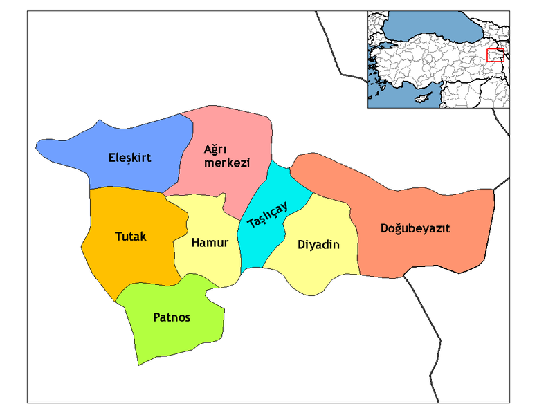
| Tigtulidong | Map of the districts of Ağrı province in Turkey. Created by Rarelibra 16:27, 1 December 2006 (UTC) for public domain use, using MapInfo Professional v8.5 and various mapping resources. Edited by One Homo Sapiens Corrected text where İ,Ş,ı,ğ,or ş occurs in name. Source: [statoids-com]. Increased font size and enhanced color differences among adjacent districts. |
| Petsa | 31 Marso 2007 (original upload date) |
| Ginkuhaan | No machine-readable source provided. Own work assumed (based on copyright claims). |
| Awtor | No machine-readable author provided. Denizz~commonswiki assumed (based on copyright claims). |
Palilisensya:
| I, the copyright holder of this work, release this work into the public domain. This applies worldwide. In some countries this may not be legally possible; if so: I grant anyone the right to use this work for any purpose, without any conditions, unless such conditions are required by law. |
Renamed by Denizz
Kaagi han paypay
Pidlita an adlaw/oras para makit-an an fayl nga naggawas hito nga oras.
| Pitsa/Oras | Thumbnail | Mga dimensyon | Gumaramit | Komento | |
|---|---|---|---|---|---|
| waray pa kasasapawi | 20:03, 28 Disyembre 2008 | | 1,056 × 816 (25 nga KB) | One Homo Sapiens | Corrected text where İ,Ş,ı,ğ,or ş occurs in name. Source: [statoids-com]. Increased font size and enhanced color differences among adjacent districts. |
| 05:49, 31 Marso 2007 |  | 1,056 × 816 (27 nga KB) | Denizz~commonswiki | == Summary == Map of the districts of Agri province in Turkey. Created by Rarelibra 16:27, 1 December 2006 (UTC) for public domain use, using MapInfo Professional v8.5 and various mapping resources. == Licensing == {{PD-self}} Renamed |
Mga Sumpay
An mga nasunod nga mga pakli nasumpay hini nga paypay:
Global file usage
An masunod nga iba nga mga wiki in nagamit hini nga file:
- Paggamit ha ar.wikipedia.org
- Paggamit ha ast.wikipedia.org
- Paggamit ha ba.wikipedia.org
- Paggamit ha bn.wikipedia.org
- Paggamit ha ca.wikipedia.org
- Paggamit ha ceb.wikipedia.org
- Paggamit ha cs.wikipedia.org
- Paggamit ha cy.wikipedia.org
- Paggamit ha de.wikipedia.org
- Ağrı (Provinz)
- Doğubeyazıt
- Ağrı
- Eleşkirt
- Diyadin
- Patnos
- Hamur (Türkei)
- Tutak
- Taşlıçay
- Vorlage:Navigationsleiste Landkreise der Provinz Ağrı
- Akçevre
- Dedebulak
- Atadamı
- Göğebakan
- Sürenkök
- Dokuztaş
- Akyolaç
- Altınkilit
- Aşağıdalören
- Aşağıkardeşli
- Vorlage:Navigationsleiste Ortschaften im Landkreis Diyadin
- Atayolu
- Batıbeyli
- Boyalan
- Burgulu
- Büvetli
- Gözüpek
- Günbuldu
- Heybeliyurt
- Kapanca
- Kocaçoban
- Kuşburnu
- Mutlu (Diyadin)
- Oğuloba
- Omuzbaşı
- Satıcılar
- Sürmelikoç (Diyadin)
- Taşbasamak
- Uysallı
- Yanıkçukur
Kitaa durudamo nga global usage hinin nga file.