Paypay:Shahrak-e Namak Abrud. Villa.jpg
Kadako hin nga pahiuna nga pagawas: 800 × 600 nga mga pixel. Iba nga mga resolusyon: 320 × 240 nga mga pixel | 640 × 480 nga mga pixel | 1,024 × 768 nga mga pixel | 1,280 × 960 nga mga pixel | 2,560 × 1,920 nga mga pixel | 3,000 × 2,250 nga mga pixel.
Orihinal nga paypay (3,000 × 2,250 nga pixel, kadako han fayl: 5.37 nga MB, MIME nga tipo: image/jpeg)
Dalikyat nga pulong
| Tigtulidong |
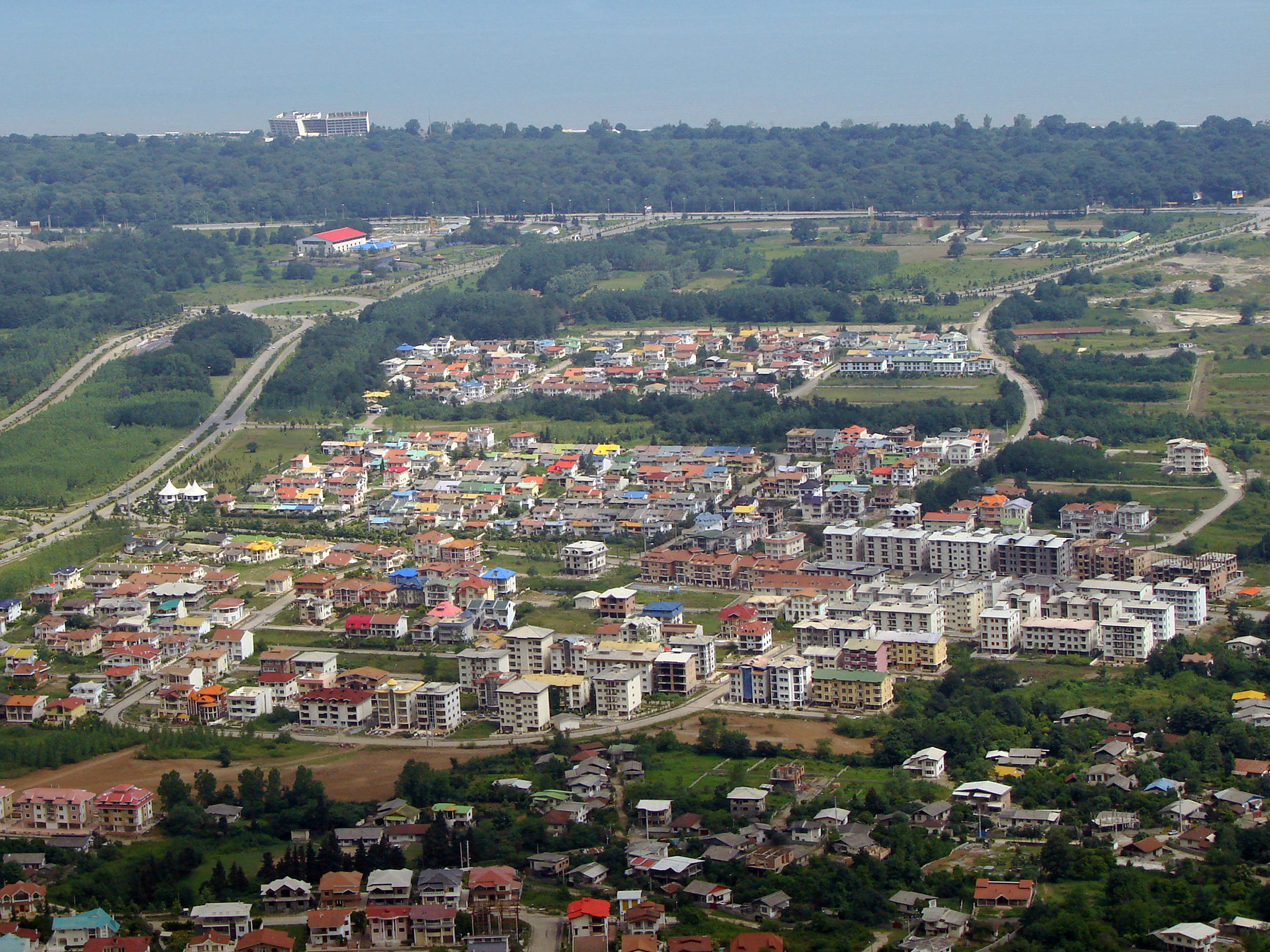
English: Shahrak-e Namak Abrud is a touristic village and has an aerial tramway which starts at the sea level near the shores of the Caspian Sea and ends on the top of the Alborz heights crossing dense forest area of northern Iran. There are numerous villa cities around it which form a vacation region for the people of Tehran.
فارسی: نمکآبرود شهرکی گردشگری و ویلایی است در استان مازندران ایران. این شهرک دارای دو خط تلهکابینی به نام تلهکابین نمکآبرود است.
شهرک نمک آبرود بین راه چالوس به تنکابن در ۱۲ کیلومتری چالوس قرار دارد.
Français : Namakabrood est situé à 12 km à l’est de Chalus et s’ettend sur une superficie de 650 hectares, avec la mer Caspienne au nord et Madoban (Alborz) au sud. Avec les parcs de violettes et la forêt dense de Madoban cette région offre des paysages splendides.
العربية: نمكآبرود (مقاطعة تشالوس) (بالإنجليزية: Shahrak-e Namak Abrud) هي مستوطنة تقع في Kelarestaq-e Gharbi Rural District في إيران.[1] يقدر عدد سكانها بـ 354 نسمة . |
| Petsa | |
| Ginkuhaan | Kalugaringon nga buhat |
| Awtor | Mostafameraji |
| Camera location | | View this and other nearby images on: OpenStreetMap |
|---|
Palilisensya:
I, the copyright holder of this work, hereby publish it under the following license:
This file is licensed under the Creative Commons Attribution-Share Alike 4.0 International license.
- Talwas ka:
- para han pagpasaro – para han pagkopya, pagpakalat ngan pagpadangat han buhat
- para han pagremix – pag-adapt han buhat
- Ha ilarom an masunod nga mga kondisyon:
- attribution – Kinahanglanon mo tagan hin kaangayan nga credit, paghatag hin sumpay ngadto ha lisensya, ngan igbutang an imo ginbag-ohan nga binuhat. Puydi mo ini buhaton ha bisan ano nga resonable nga pamaagi, pero diri nimo pagawson nga an naghatag hin lisensya nag-eendorso ha imo o ha imo paggamit.
- share alike – Kun imo ginsagol-hin-otro, gin-iba, o gin-hingayad han buhat, ikaw in angay gud là magpakalat han imo gin-amot ha ilarom la han [http:creativecommons.org/share-your-work/licensing-considerations/compatible-licenses pareho o naangay nga lisensya] sugad han orihinal.
| Annotations | This image is annotated: View the annotations at Commons |
Kaagi han paypay
Pidlita an adlaw/oras para makit-an an fayl nga naggawas hito nga oras.
| Pitsa/Oras | Thumbnail | Mga dimensyon | Gumaramit | Komento | |
|---|---|---|---|---|---|
| waray pa kasasapawi | 05:48, 8 Enero 2017 | | 3,000 × 2,250 (5.37 nga MB) | Mostafameraji | User created page with UploadWizard |
Mga Sumpay
An mga nasunod nga mga pakli nasumpay hini nga paypay:
Global file usage
An masunod nga iba nga mga wiki in nagamit hini nga file:
- Paggamit ha bg.wikipedia.org
- Paggamit ha en.wikibooks.org
- Paggamit ha fa.wikipedia.org
- Paggamit ha id.wikipedia.org
- Paggamit ha is.wikipedia.org
- Paggamit ha ko.wikipedia.org
- Paggamit ha la.wikipedia.org
- Paggamit ha lv.wikipedia.org
- Paggamit ha my.wikipedia.org
- Paggamit ha th.wikipedia.org
- Paggamit ha ur.wikipedia.org
- Paggamit ha vi.wikipedia.org
- Paggamit ha zh.wikipedia.org
- Paggamit ha zu.wikipedia.org