Paypay:Lena watershed.png
Waray mas hiruhitaas nga resolusyon.
Lena_watershed.png (500 × 500 nga pixel, kadako han fayl: 138 nga KB, MIME nga tipo: image/png)
Dalikyat nga pulong
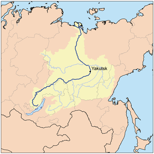
| Tigtulidong | This is a map of the Lena River Watershed. I, Karl Musser, created it based on USGS data. |
| Petsa | 11 Abril 2006 (original upload date) |
| Ginkuhaan | No machine-readable source provided. Own work assumed (based on copyright claims). |
| Awtor | No machine-readable author provided. Kmusser assumed (based on copyright claims). |
Palilisensya:
I, the copyright holder of this work, hereby publish it under the following license:
This file is licensed under the Creative Commons Attribution-Share Alike 2.5 Generic license.
- Talwas ka:
- para han pagpasaro – para han pagkopya, pagpakalat ngan pagpadangat han buhat
- para han pagremix – pag-adapt han buhat
- Ha ilarom an masunod nga mga kondisyon:
- attribution – Kinahanglanon mo tagan hin kaangayan nga credit, paghatag hin sumpay ngadto ha lisensya, ngan igbutang an imo ginbag-ohan nga binuhat. Puydi mo ini buhaton ha bisan ano nga resonable nga pamaagi, pero diri nimo pagawson nga an naghatag hin lisensya nag-eendorso ha imo o ha imo paggamit.
- share alike – Kun imo ginsagol-hin-otro, gin-iba, o gin-hingayad han buhat, ikaw in angay gud là magpakalat han imo gin-amot ha ilarom la han [http:creativecommons.org/share-your-work/licensing-considerations/compatible-licenses pareho o naangay nga lisensya] sugad han orihinal.
Kaagi han paypay
Pidlita an adlaw/oras para makit-an an fayl nga naggawas hito nga oras.
| Pitsa/Oras | Thumbnail | Mga dimensyon | Gumaramit | Komento | |
|---|---|---|---|---|---|
| waray pa kasasapawi | 19:59, 17 Septyembre 2007 | | 500 × 500 (138 nga KB) | Kmusser | added tributaries, upped resolution |
| 17:01, 11 Abril 2006 |  | 300 × 300 (18 nga KB) | Kmusser | This is a map of the Lena River Watershed. I, Karl Musser, created it based on USGS data. {{GFDL}} Category:Maps of rivers |
Mga Sumpay
An mga nasunod nga mga pakli nasumpay hini nga paypay:
Global file usage
An masunod nga iba nga mga wiki in nagamit hini nga file:
- Paggamit ha af.wikipedia.org
- Paggamit ha ast.wikipedia.org
- Paggamit ha avk.wikipedia.org
- Teza:AldanKuksa
- Teza:LenaBost
- Teza:VilyuyKuksa
- Aldan (kuksa)
- Allax-Yun (kuksa)
- Ameditci (kuksa)
- Amga (kuksa)
- Axtaranda (kuksa)
- Yudoma (kuksa)
- Vilyuy (kuksa)
- Ulaxan-Botuobuya (kuksa)
- Ungra (kuksa)
- Utcur (kuksa)
- Tyukyan (kuksa)
- Tyung (kuksa)
- Tiri (kuksa)
- Tompo (kuksa)
- Tcona (kuksa)
- Tculman (kuksa)
- Timpton (kuksa)
- Tcilli (kuksa)
- Tatta (kuksa)
- Tangnari (kuksa)
- Gonam (kuksa)
- Igiatta (kuksa)
- Lena
- Marxa (kuksa)
- Maya (kuksa)
- Morkoka (kuksa)
- Notora (kuksa)
- Otcuguy-Botuobuya (kuksa)
- Olyokma (kuksa)
- Teza:OlyokmaKuksa
- Tungir (kuksa)
- Nyukja (kuksa)
- Tcara (kuksa)
- Vitim (kuksa)
- Kalar (kuksa)
- Kalakan (kuksa)
- Karenga (kuksa)
- Yumurtcen (kuksa)
- Tsipa (kuksa)
- Teza:VitimKuksa
- Kuanda (kuksa)
- Mamakan (kuksa)
- Mama (kuksa)
- Muya (kuksa)
- Zaza (kuksa)
Kitaa durudamo nga global usage hinin nga file.